Difference between revisions of "Carrick Roads"
(Created page with "Carrick Roads, seen from Roseland {{county|Cornwall}} '''Carrick Roads''' is a capacious roadstead formed of the estuary...") |
m |
||
| (One intermediate revision by one other user not shown) | |||
| Line 3: | Line 3: | ||
'''Carrick Roads''' is a capacious roadstead formed of the estuary of the [[River Fal]] on the south coast of [[Cornwall]]. It is a deep, broad yet sheltered natural harbour opening into the [[English Channel]] at its southern end near [[Falmouth]]. | '''Carrick Roads''' is a capacious roadstead formed of the estuary of the [[River Fal]] on the south coast of [[Cornwall]]. It is a deep, broad yet sheltered natural harbour opening into the [[English Channel]] at its southern end near [[Falmouth]]. | ||
| − | The roadstead is a large flooded valley known as a 'ria', created after the Ice Age as the sea level rose dramatically: other examples along this coast are the [[Hamoaze]], the [[River Teign|Teign Estuary]], [[River Exe|Exe Estuary], [[Poole | + | The roadstead is a large flooded valley known as a 'ria', created after the Ice Age as the sea level rose dramatically: other examples along this coast are the [[Hamoaze]], the [[River Teign|Teign Estuary]], [[River Exe|Exe Estuary]], [[Poole Harbour]] and [[Southampton Water]]. The result is a large natural harbour which is navigable from Falmouth to [[Truro]]. |
The Falmouth Harbour Commissioners<ref>{{cite web|url=http://www.falmouthport.co.uk/index.php |title=Falmouth Harbour Commissioners Home |publisher=Falmouthport.co.uk |date=|accessdate=2012-02-04}}</ref> are the statutory port authority with responsibility for the Inner Harbour at Falmouth (excluding [[Falmouth Docks]]), the [[Penryn]] River up as far as [[Boyers Cellars]], the southern part of the Carrick Roads and a large part of Falmouth Bay. | The Falmouth Harbour Commissioners<ref>{{cite web|url=http://www.falmouthport.co.uk/index.php |title=Falmouth Harbour Commissioners Home |publisher=Falmouthport.co.uk |date=|accessdate=2012-02-04}}</ref> are the statutory port authority with responsibility for the Inner Harbour at Falmouth (excluding [[Falmouth Docks]]), the [[Penryn]] River up as far as [[Boyers Cellars]], the southern part of the Carrick Roads and a large part of Falmouth Bay. | ||
| Line 26: | Line 26: | ||
{{reflist}} | {{reflist}} | ||
| − | [[Category: | + | [[Category:Bays of Cornwall]] |
Latest revision as of 21:23, 24 May 2016

Carrick Roads is a capacious roadstead formed of the estuary of the River Fal on the south coast of Cornwall. It is a deep, broad yet sheltered natural harbour opening into the English Channel at its southern end near Falmouth.
The roadstead is a large flooded valley known as a 'ria', created after the Ice Age as the sea level rose dramatically: other examples along this coast are the Hamoaze, the Teign Estuary, Exe Estuary, Poole Harbour and Southampton Water. The result is a large natural harbour which is navigable from Falmouth to Truro.
The Falmouth Harbour Commissioners[1] are the statutory port authority with responsibility for the Inner Harbour at Falmouth (excluding Falmouth Docks), the Penryn River up as far as Boyers Cellars, the southern part of the Carrick Roads and a large part of Falmouth Bay.
The Roads are crossed by the historic and scenic King Harry Ferry, a vehicular chain ferry that links the parishes of Feock and Philleigh.
In the Cornish language this water was known as Dowr Carrek, meaning "rock water" (or “anchorage”)[2] It is named after Black Rock (Cornish: Karrek Reun, meaning seal rock) which lies between Pendennis Point, St Mawes, and Carricknath Point.
Pictures
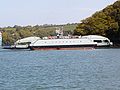
King Harry Ferry between Trelissick and Roseland

Carrick Roads near Trelissick
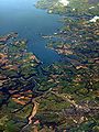
An aerial view showing Carrick Roads, Truro and Falmouth
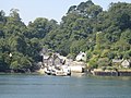
The Feock terminal of the King Harry Ferry in 2005

Carrick Roads in Cornwall bordered by Penryn, Falmouth & St. Mawes. Taken from flight AF0349


Outside links
- Location map: 50°11’25"N, 5°2’12"W
- Streetmap: SW833366
References
- ↑ "Falmouth Harbour Commissioners Home". Falmouthport.co.uk. http://www.falmouthport.co.uk/index.php. Retrieved 2012-02-04.
- ↑ Weatherhill, Craig (2009). A Concise Dictionary of Cornish Place-Names. Westport, Co. Mayo: Evertype. ISBN 9781904808220; p. 9