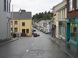
Newtownhamilton: Difference between revisions
Created page with '{{Infobox town |name=Newtownhamilton |county=Armagh |picture= |picture caption= |os grid ref=H9227 |LG district=Newry & Mourne }} '''Newtownhamilton''' is a village in [[County A…' |
No edit summary |
||
| Line 1: | Line 1: | ||
{{Infobox town | {{Infobox town | ||
|county=Armagh | |county=Armagh | ||
|picture= | |irish=An Baile Úr | ||
|picture | |picture=Village Centre - Newtownhamilton - geograph.org.uk - 547838.jpg | ||
|os grid ref= | |picture cation=Newtownhamilton village centre | ||
| | |latitude=54.19058 | ||
|longitude=-6.57644 | |||
|population = 2,836 | |||
|census year=2011 | |||
|os grid ref= H930278 | |||
|post_town=Newry | |||
|postcode= BT35 | |||
|dialling code= 028 | |||
|constituency=Newry & Armagh | |||
}} | }} | ||
'''Newtownhamilton''' is a village in [[County Armagh]]. | '''Newtownhamilton''', sometimes referred to as '''Newtown''', is a small village and parish in [[County Armagh]]. It lies in [[Tullyvallan]] [[townland]]. The parish is within the barony of [[Fews Upper]].<ref name=Ire>{{cite web|title=Newtownhamilton|url=http://www.thecore.com/seanruad/|website=IreAtlas Townlands Database|accessdate=13 May 2015}}</ref> In the 2011 Census it had 2,836 inhabitants. | ||
{{ | The village is built around two narrow main streets (Armagh Street and Dundalk Street) and a town square (The Square). Other places include Newry Street, Castleblaney Street (known locally as 'Blaney Hill'), Shambles Lane (known locally as the 'back street') and The Commons. Residential areas are Dungormley Estate, Meadowvale and the Nine Mile Road. | ||
== Name == | |||
Before the Plantation of Ulster the area of Newtownhamilton was known as Tullyvallan. This is derived from the Irish language, either ''Tulaigh Mhalainn'' or ''Tulach Uí Mhealláin''. | |||
The modern Irish name of Newtownhamilton is ''An Baile Úr'', literally translating as "the new town"; a rarely used alternative is ''Baile Úr Uí Urmoltaigh'' ("the new town of Hamilton"). The local authority, has erected bilingual welcome signs (reading ''Fáilte go dtí An Baile Úr / Welcome to Newtownhamilton'') at the town end points on Newry Road and Dundalk Road, both in the perceived nationalist areas of Newtownhamilton, while a sign in English only was erected on Armagh Road, a perceived unionist area of the village. It is not known if this reflects official council policy. | |||
== History == | |||
The village takes its name from Alexander Hamilton, a descendant of the John Hamilton from [[Scotland]] who founded [[Hamiltonsbawn]] in 1619. The parish was created in 1773 out of the neighbouring parish of Creggan. | |||
==Parish of Newtownhamilton== | |||
The parish contains the village of Newtownhamilton.<ref name=Ire/> | |||
===Townlands=== | |||
The parish contains the following townlands:<ref name=Ire/> | |||
{{townlandliststart}} | |||
*[[Altnamackan]] | |||
*[[Ballynarea]] | |||
*[[Camly (Ball)]] | |||
*[[Camly (Macullagh)]] | |||
*[[Carrickacullion]] | |||
*[[Carrickrovaddy]], also known as [[Dorsy (Macdonald)]] | |||
*[[Dorsy (Hearty)]] | |||
*[[Dorsy (Mullaghglass)]] | |||
*[[Drumaltnamuck]] | |||
*[[Kiltybane]], also known as Lisleitrim | |||
*[[Mullaghduff, County Armagh|Mullaghduff]] | |||
*[[Roxborough, County Armagh|Roxborough]] also known as Dorsy (Cavan O'Hanlon) | |||
*[[Skerriff (Tichburn)]] | |||
*[[Skerriff (Trueman)]] | |||
*[[Tullyogallaghan]] | |||
*[[Tullyvallan]] | |||
*[[Tullyvallan (Hamilton) East]] | |||
*[[Tullyvallan (Hamilton) West]] | |||
*[[Tullyvallan (Macullagh)]] | |||
*[[Tullyvallan (Tipping) East]] | |||
*[[Tullyvallan (Tipping) West]] | |||
*[[Ummerinvore]] | |||
{{townlandlistend}} | |||
==References== | |||
{{reflist}} | |||
==Sources== | |||
*[http://www.culturenorthernireland.org/town_Home.aspx?co=3&to=55&ca=0&sca=0&navID=1 Culture Northern Ireland] | |||
Latest revision as of 09:49, 11 November 2015
| Newtownhamilton Irish: An Baile Úr | |
| County Armagh | |
|---|---|

| |
| Location | |
| Grid reference: | H930278 |
| Location: | 54°11’26"N, 6°34’35"W |
| Data | |
| Population: | 2,836 (2011) |
| Postcode: | BT35 |
| Dialling code: | 028 |
| Local Government | |
| Parliamentary constituency: |
Newry & Armagh |
Newtownhamilton, sometimes referred to as Newtown, is a small village and parish in County Armagh. It lies in Tullyvallan townland. The parish is within the barony of Fews Upper.[1] In the 2011 Census it had 2,836 inhabitants.
The village is built around two narrow main streets (Armagh Street and Dundalk Street) and a town square (The Square). Other places include Newry Street, Castleblaney Street (known locally as 'Blaney Hill'), Shambles Lane (known locally as the 'back street') and The Commons. Residential areas are Dungormley Estate, Meadowvale and the Nine Mile Road.
Name
Before the Plantation of Ulster the area of Newtownhamilton was known as Tullyvallan. This is derived from the Irish language, either Tulaigh Mhalainn or Tulach Uí Mhealláin.
The modern Irish name of Newtownhamilton is An Baile Úr, literally translating as "the new town"; a rarely used alternative is Baile Úr Uí Urmoltaigh ("the new town of Hamilton"). The local authority, has erected bilingual welcome signs (reading Fáilte go dtí An Baile Úr / Welcome to Newtownhamilton) at the town end points on Newry Road and Dundalk Road, both in the perceived nationalist areas of Newtownhamilton, while a sign in English only was erected on Armagh Road, a perceived unionist area of the village. It is not known if this reflects official council policy.
History
The village takes its name from Alexander Hamilton, a descendant of the John Hamilton from Scotland who founded Hamiltonsbawn in 1619. The parish was created in 1773 out of the neighbouring parish of Creggan.
Parish of Newtownhamilton
The parish contains the village of Newtownhamilton.[1]
Townlands
The parish contains the following townlands:[1]
- Altnamackan
- Ballynarea
- Camly (Ball)
- Camly (Macullagh)
- Carrickacullion
- Carrickrovaddy, also known as Dorsy (Macdonald)
- Dorsy (Hearty)
- Dorsy (Mullaghglass)
- Drumaltnamuck
- Kiltybane, also known as Lisleitrim
- Mullaghduff
- Roxborough also known as Dorsy (Cavan O'Hanlon)
- Skerriff (Tichburn)
- Skerriff (Trueman)
- Tullyogallaghan
- Tullyvallan
- Tullyvallan (Hamilton) East
- Tullyvallan (Hamilton) West
- Tullyvallan (Macullagh)
- Tullyvallan (Tipping) East
- Tullyvallan (Tipping) West
- Ummerinvore
References
- ↑ 1.0 1.1 1.2 "Newtownhamilton". http://www.thecore.com/seanruad/. Retrieved 13 May 2015.