Prees: Difference between revisions
Created page with "{{Infobox town |name=Prees |county=Shropshire |picture=Prees Church - geograph.org.uk - 82321.jpg |picture caption=St Chad's church, Prees |os grid ref=SJ553335 |latitude=52...." |
mNo edit summary |
||
| Line 15: | Line 15: | ||
|constituency=North Shropshire | |constituency=North Shropshire | ||
}} | }} | ||
'''Prees''' is a village in north [[Shropshire]], near the border of [[ | '''Prees''' is a village in north [[Shropshire]], near the border of [[Flintshire]]. Its name is Welsh and means "brushwood". | ||
Near to the village of Prees, but not in the village, is Prees railway station, on the Welsh Marches Line, between [[Whitchurch, Shropshire|Whitchurch]] and [[Wem]]. It is reported that the station is outside the village because Captain Black, a wealthy resident in the village stated that the station had to be exactly one mile away from the centre of the village, which at the time was the mill, which stands on Mill Street, so that the station could be easily reached as a route out with the goods produced. | Near to the village of Prees, but not in the village, is Prees railway station, on the Welsh Marches Line, between [[Whitchurch, Shropshire|Whitchurch]] and [[Wem]]. It is reported that the station is outside the village because Captain Black, a wealthy resident in the village stated that the station had to be exactly one mile away from the centre of the village, which at the time was the mill, which stands on Mill Street, so that the station could be easily reached as a route out with the goods produced. | ||
Latest revision as of 12:33, 24 June 2015
| Prees | |
| Shropshire | |
|---|---|
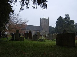
 St Chad's church, Prees | |
| Location | |
| Grid reference: | SJ553335 |
| Location: | 52°53’49"N, 2°39’58"W |
| Data | |
| Population: | 2,688 (2001) |
| Post town: | Whitchurch |
| Postcode: | SY13 |
| Dialling code: | 01948 |
| Local Government | |
| Council: | Shropshire |
| Parliamentary constituency: |
North Shropshire |
Prees is a village in north Shropshire, near the border of Flintshire. Its name is Welsh and means "brushwood".
Near to the village of Prees, but not in the village, is Prees railway station, on the Welsh Marches Line, between Whitchurch and Wem. It is reported that the station is outside the village because Captain Black, a wealthy resident in the village stated that the station had to be exactly one mile away from the centre of the village, which at the time was the mill, which stands on Mill Street, so that the station could be easily reached as a route out with the goods produced.
Prees is northeast of the small town of Wem. It is also west of Market Drayton and south of Whitchurch. A number of nearby villages share the name Prees: Prees Village, Prees Green, Prees Heath and Prees Wood. All were formerly known as Prys - Wood or Prys, etc. The population in 2001 was recorded at 2,688.
The church in the village dates back to the 14th century, however the tower is younger.
The A41 and A49 roads pass on either side of the village.
Persons associated with Prees include Captain Black, whose manor is located near the war memorial, and Rowland Hill, 1st Viscount Hill, whose Doric column stands in Shrewsbury.
Also located in Prees is the Prees Church of England Primary School and Nursery, a Victorian building that holds much history.

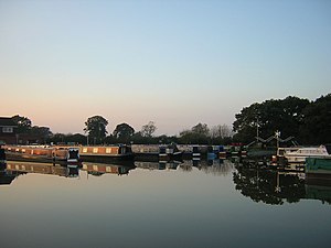
Prees was the intended destination of an arm of the Ellesmere Canal. However the arm was only completed as far as Quina Brook. The arm is now known as the Prees Branch of the Llangollen Canal; it is navigable for about a mile to Whixall Marina and the following ¾ mile can be followed on the towpath as it passes through Prees Branch Canal Nature Reserve.[1]
Outside links
| ("Wikimedia Commons" has material about Prees) |
