Strathfinella Hill: Difference between revisions
Jump to navigation
Jump to search
Created page with "{{Infobox hill |name=Strathfinella Hill |county=Kincardineshire |picture=Strathfinella Hill - geograph.org.uk - 114934.jpg |os grid ref=NO693787 |latitude=56.899033 |longitude..." |
No edit summary |
||
| Line 13: | Line 13: | ||
[[File:Strathfinella Hill (Kincardineshire), summit trig point - geograph-2546761.jpg|left|thumb|250px|Summit trig point]] | [[File:Strathfinella Hill (Kincardineshire), summit trig point - geograph-2546761.jpg|left|thumb|250px|Summit trig point]] | ||
Latest revision as of 23:00, 9 April 2015
| Strathfinella Hill | |
| Kincardineshire | |
|---|---|

| |
| Summit: | 1,358 feet NO693787 56°53’57"N, 2°30’18"W |
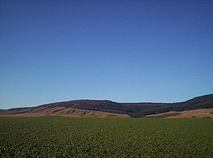
Strathfinella Hill is a long hill at the edge of the flat plain of the Howe o' the Mearns, in Kincardineshire - the hill marks the abrupt finish of the Howe. The old county town, the vanished burgh of Kincardine, sat at its foot.
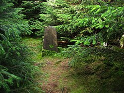
Much of the hill is forested. At its summit is a trig pillar, incongruously placed in the middle of the wood without sight lines.
