Watlington, Norfolk
| Watlington | |
| Norfolk | |
|---|---|
 St Peter and Paul Church, Watlington | |
| Location | |
| Grid reference: | TF619111 |
| Location: | 52°40’24"N, -0°23’35"E |
| Data | |
| Population: | 2,455 (2011) |
| Post town: | King's Lynn |
| Postcode: | PE33 |
| Local Government | |
| Council: | King's Lynn and West Norfolk |
Watlington is a village in Norfolk, in the heart of a parish with a population of 2,455 at the 2011 Census. The village is found just over a mile from the east bank of the Great Ouse, seven and a half miles south of the county’s north market town, King's Lynn, and 37 miles west of the county town, the City of Norwich.
The village’s name means 'farm/settlement of Hwætel's or Wacol's people' or perhaps, 'farm/settlement at Wateling', or from wattle used in thatching.[1]
The village has its own railway station, Watlington station, on the 'Fen Line' between Cambridge and King's Lynn: the station is half a mile from the centre of the village.
Watlington has a pub, a post office and medical centre with pharmacy. There is also a sports and social club, village hall and church to the north-east of the village.
A small nature reserve named 'Watatunga' opened to visitors in July 2020, offering guided buggy tours amongst '170 acres of woodland, grassland and lakes'. This occupies a vast area directly situated between Watlington and the nearby A10 trunk road.[2]
Pictures
| ("Wikimedia Commons" has material about Watlington, Norfolk) |
-
 Watlington's village sign.
 -
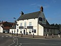 The Angel pub
 -
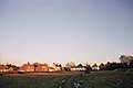 Millennium Green (also known as Angel Field)
 -
 Watlington railway station


Outside links
- Watlington Village
- Information from Genuki Norfolk on Watlington
References
- ↑ Place-Names of Norfolk: English Place-Names Society
- ↑ "Guided Tours". 11 February 2020. https://www.watatunga.co.uk/guided-tours/.