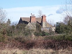
Twyford, Derbyshire
| Twyford | |
| Derbyshire | |
|---|---|
 Old Hall Cottage, Twyford | |
| Location | |
| Grid reference: | SK327284 |
| Location: | 52°51’10"N, 1°30’57"W |
| Data | |
| Postcode: | DE73 |
| Local Government | |
| Council: | South Derbyshire |
Twyford Is a hamlet on the north bank of the River Trent in the very south of Derbyshire, equidistant between Willngton a mile and a half to the west, Barrow upon Trent to the east, and the outer edge of the swollen suburbs of Derby to the north.
In the Domesday Book of 1086, Twyford and neighbouring Stenson are listed under the lands of Henry de Ferrers:
In Twyford and Stenson Leofric had four carucates of land to the geld. There is land for three ploughs. There are now two ploughs in demesne and four villeins and five bordars with one plough and one mill rendering 5 shillings have one plough. There is one mill rendering 2 shillings and 24 acres of meadow, woodland pasture one furlong long and one much broad. In the time of King Edward worth eight pounds now four pounds.
St Andrew's Church at Twyford is an unusual sight as from the outside it appears to be of brick construction with stone extensions and steeple. In fact the brickwork is just the facing,. as internal investigation reveals. It stands about 220 yards from the River Trent which floods every winter but never, it seems, has the church been flooded. However it has been damaged by lightning in 1821 and a fire in 1910. The lower part of the tower dates from 1200. Local tradition tells of food being handed out to wayfarers from a stone-framed window in a nearby farmhouse. This charity was administered by monks from a religious house of the Knights Hospitallers at the village of Arleston.
Outside links
| ("Wikimedia Commons" has material about Twyford, Derbyshire) |
