Tokyngton
| Tokyngton | |
| Middlesex | |
|---|---|
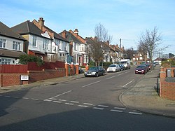
 Junction of Tokyngton Avenue | |
| Location | |
| Grid reference: | TQ175855 |
| Location: | 51°32’51"N, 0°16’37"W |
| Data | |
| Population: | 15,105 (2011) |
| Post town: | Wembley |
| Postcode: | HA9 |
| Dialling code: | 020 |
| Local Government | |
| Council: | Brent |
| Parliamentary constituency: |
Brent North |
Tokyngton, also locally known as Monks Park, is a locality that forms the southeastern part of the town of Wembley in Middlesex. The name Tokyngton has been squeezed out of popualr speech even amongst its inhabitants is hardly used by locals and is not mentioned on street signs, except for street names and public places bearing the name.
Tokyngton was first mentioned in 1171, its name from the Old English Tocinga tun meaning "Toca's sons' farmstead".
The area is served by two stations: Stonebridge Park on the Bakerloo and Watford DC Lines, and Wembley Stadium on the Chiltern Main Line.
Location

Tokyngton is situated roughly east of Wembley itself. The main road through the area is the A404 Harrow Road, which runs from southeast to northwest; the A406 North Circular Road passes to the south-east, separated from the area by the River Brent.
The area mostly consists of Edwardian terraces and 1930s semi-detached housing. There are three schools in the area: Oakington Manor Primary School in the northeast, and Elsley Primary School and St Joseph's Catholic Junior School in the west. There is also a community centre within Sherrans Farm Open Space in the north of the area, close to Wembley Stadium. Tokyngton Library, in the southeast, closed in 2011.[1]
Sport and leisure
- Football: Tokyngton Manor F.C., which plays at Spratleys Meadow.
References
- ↑ Walters, Max (9 February 2013). "Tokyngton Library site to be sold off". Brent & Kilburn Times. http://www.kilburntimes.co.uk/news/tokyngton_library_site_to_be_sold_off_1_1885074. Retrieved 12 September 2015.