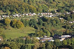
Thrupp, Gloucestershire
Jump to navigation
Jump to search
| Thrupp | |
| Gloucestershire | |
|---|---|

| |
| Location | |
| Grid reference: | SO862038 |
| Location: | 51°44’1"N, 2°12’4"W |
| Data | |
| Post town: | Stroud |
| Postcode: | GL5 |
| Local Government | |
| Council: | Stroud |
| Parliamentary constituency: |
Stroud |
Thrupp is a village in Gloucestershire, in the Cotswolds immediately south-east of Stroud.
Thrupp is a thin village pressed along a lane above and parallel to the steep valley of the River Frome running north-south, and above the A419 Stroud to Cirencester road which follows the valley bottom here.
A slightly more substantial village immediately adjoining to the south, is Far Thrupp.
The down above the village once held the vanished village of Nether Lypiatt, which still gives its name to the manor house there.
Far Thrupp
 |
|
Far Thrupp has grown a little larger than its parent village, Thrupp. It continues to run along the same lane above the Frome Valley, but also spreads down the hill to the A419.

See also
- Nether Lypiatt Manor, east of Thrupp
Outside links
| ("Wikimedia Commons" has material about Thrupp, Gloucestershire) |