Takeley
| Takeley | |
| Essex | |
|---|---|
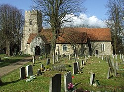
 Holy Trinity Church, Takeley | |
| Location | |
| Grid reference: | TL561212 |
| Location: | 51°52’5"N, -0°15’58"E |
| Data | |
| Population: | 3,367 (2011[1]) |
| Post town: | Bishop's Stortford |
| Postcode: | CM22 |
| Dialling code: | 01279 |
| Local Government | |
| Council: | Uttlesford |
| Parliamentary constituency: |
Saffron Walden |
Takeley is a village and parish in the Uttlesford hundred of Essex.
The village is situated approximately halfway between Bishop's Stortford and Great Dunmow, and on Stane Street, the Roman road from Braughing to Colchester. The A120 road and Stansted Airport is at the north.
Takeley consists of a number of 'Ends' and 'Greens', namely Brewer's End (John le Brewer, 1327), The Street, Smith's Green, Bamber's Green (Bambrose Green, from the Banbury family at Sheering Hall), Molehill Green (Morrell's Green), and Mill End.
When Takeley was first recorded by the Normans in 1086–87 its boundaries were approximately eight miles in length, with a total area of 3,000 acres. However, since the development of Stansted Airport, the civil parish has lost nearly a third of its land.
The previous Cooper's End was demolished and the cargo area of Stansted Airport stands on the ground once occupied by the settlement. The access to and from the airport at Cooper's End was closed briefly in January 1991 but was re-opened in November of that year. Cooper's End roundabout was constructed as part of the new airport, and is just west of the terminal.
Takeley parish church, dating from the 12th century, is dedicated to the Holy Trinity, and was Grade-I listed in 1967.[2]
Takeley has a non-League football club, Takeley Football Club, who play at Station Road. They were members of the Essex Olympian League in 2007–08, and entered the Essex Senior League in 2008–09.[3] The Cricket team at Takeley was established circa 1880.
References
- ↑ "Civil Parish population 2011". http://www.neighbourhood.statistics.gov.uk/dissemination/LeadKeyFigures.do?a=7&b=11129421&c=Takeley&d=16&e=62&g=6426441&i=1001x1003x1032x1004&m=0&r=1&s=1443361488538&enc=1. Retrieved 27 September 2015.
- ↑ National Heritage List 1168843: Church of the Holy Trinity, Church Lane
- ↑ Takeley Football Club. Retrieved 4 July 2013
Outside links
| ("Wikimedia Commons" has material about Takeley) |
This Essex article is a stub: help to improve Wikishire by building it up.