Stapleton-on-Tees
| Stapleton-on-Tees | |
| Yorkshire North Riding | |
|---|---|
 Stapleton village green | |
| Location | |
| Grid reference: | NZ263121 |
| Location: | 54°30’14"N, 1°35’39"W |
| Data | |
| Population: | 179 (2011) |
| Post town: | Darlington |
| Postcode: | DL2 |
| Local Government | |
| Council: | North Yorkshire |
| Parliamentary constituency: |
Richmond (North Yorks) |
Stapleton-on-Tees is a small village on the south bank of the River Tees, in the North Riding of Yorkshire.
There is some dispute of the origin of the name 'Stapleton'. Historian Henry Chetwynd-Stapylton (quoting Samuel Johnson) states in 1884 that the first part of the name, 'staple', originated from the word 'stapel' meaning a trading position or a place where goods for sale are stored.[1] Another theory, however, puts forward that 'staple' originates from an Old English word 'stapol' meaning boundary, which is also plausible.
History
Stapleton appears in the Domesday Book of 1086.[2] It has been known that a settlement has existed on this sharp bend in the river since the 9th century. William the Conqueror grabted the manor and lands about the village to a knight who would become known as Benedict de Stapleton. One member of the Stapleton family, Miles Stapleton of Bedale was one of the founding members of the Order of the Garter. The family built a manor in the village as well as a private chapel named after St James.
In the 13th century the 'de Stapleton' family gave some lands around the village to the nearby Premonstratensian monks of Easby Abbey and in so doing forgoing the obligation to maintain a ferryboat across the river. The settlement had a second church known as St Leonard's, which was administered by Easby Abbey. Neither the manor nor either of the two churches exist today. However, local speculation suggests that the site of the manor is located in 'Garth Field', the irregularity of the land being the last remnants of a defensive moat or pond.[3]
By 1616 the Stapleton family had left the village and the churches fell out of use, following this, the village was served by the 12th century Church of St Peter in Croft-on-Tees. This is thought to be the origin of the local name given to the path to the nearby village of Croft, the 'Corpse Walk', so named as the deceased of the village had to be carried from Stapleton to Croft;, a distance of some three miles.
During the Middle Ages, a bridge linked the village to the northern bank of the river and a ferry had existed before that.[3] It is believed that this gave the village's only public house (The Bridge Inn) its name.[4] This bridge however was lost after a flood and was not replaced, meaning that the nearest crossing was at Croft-on-Tees until 1832 when the Blackwell Bridge was built.
In 1945 the village was used as a filming location for the film Way to the Stars. Until the second half of the 20th century the village was served by a post office, a blacksmith and a public house. Only the latter is still in use.
Pictures
| ("Wikimedia Commons" has material about Stapleton-on-Tees) |

-
 The Marquess of Zetland's hounds on the green (1870s)
 -
 Stapleton green in the snow
 -
 Late Georgian cottages by the village green.
 -
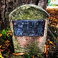 Memorial to Wilfred Thornton on the green


Outside links
| ("Wikimedia Commons" has material about Stapleton-on-Tees) |
References
- ↑ Henry Edward Chetwynd-Stapylton (in English). Chronicles of the Yorkshire family of Stapelton. Oxford University. Yorkshire Archaeological and Topographical Journal, 1884. https://archive.org/details/chroniclesyorks00chetgoog.
- ↑ Yorkshire: North Riding: Internet Domesday Book
- ↑ 3.0 3.1 A History of the County of York: North Riding - Volume 1 pp 162-171: Parishes: Croft (Victoria County History)
- ↑ Lloyd, Chris (9 February 2010). "The story of Stapleton". The Northern Echo. http://www.thenorthernecho.co.uk/news/4997419.The_story_of_Stapleton/. Retrieved 24 May 2018.