Nethercote, Buckinghamshire
| Nethercote | |
| Buckinghamshire | |
|---|---|
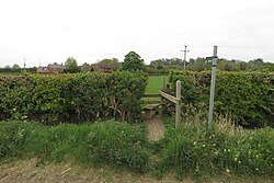
 Across the field to Meadow House, Nethercote | |
| Location | |
| Grid reference: | SP475414 |
| Location: | 52°4’3"N, 1°18’18"W |
| Data | |
| Post town: | Banbury |
| Postcode: | OX17 |
| Dialling code: | 01295 |
| Local Government | |
| Council: | Cherwell |
| Parliamentary constituency: |
Banbury |
Nethercote is a hamlet in Buckinghamshire, just to the east of the unforgiving path of the M40 motorway which separates it from Grimsbury, a suburb on the Oxfordshire border.
This is a semi-rural position, predominantly agricultural land used for grazing, a single-track road runs right through the hamlet, known as Banbury Lane, which has around a dozen residential properties along the lane. Banbury Lane is still often referred to as Blacklocks Hill and this refers to the history of the area and a time when this area saw a main route into Banbury, before the M40 and A422. In 1870-72 it had a population of 97.[1]
History
The name Nethercote is thought to have derived from the proximity to Warkworth. The word Nethercote is derived from the Middle English for 'lower cottage'.
An open field system of farming prevailed in Warkworth Parish (including Nethercote) until the 18th century. Its land tenure was linked with that of Overthorpe and Nethercote, which at that time was part of Middleton Cheney parish. Parliament passed a single Inclosure Act for both Overthorpe and Warkworth in 1764.[2] Today only Nethercote has ridge and furrow land form remaining from these times
Throughout the Middle Ages until the mid-eighteenth century, Nethercote along with the original hamlet of Grimsbury was the centre of nearby Banbury's cheese making trade, a product that was made from local resources and much prized at the time, although there is little mention of it by the nineteenth century.[3]
Klaus Fuchs is said to have handed over the secret formula of the atom bomb to a Russian spy on a bench in Nethercote in 1945.[4]
References
- ↑ "Descriptive gazetteer entry for Nethercote". A Vision of Britain through Time. https://visionofbritain.org.uk/descriptions/983690. Retrieved 25 November 2021.
- ↑ RCHME 1982, pp. 101–102.
- ↑ "Nethercote: History | Cherwell District Council History of Grimsbury". http://modgov.cherwell.gov.uk/Data/Executive/20061106/Agenda/08a%20Grimsbury%20appraisal%20DND.pdf.
- ↑ "Nethercote: History | The History of the Villages of Overthorpe and Warkworth in Northamptonshire". http://overthorpe.org/images/assets/Misc/The_Ancient_and_Noble_Seat_S_Rutherford-Edge.pdf.