Longsleddale

Longsleddale is a long, steep valley in Westmorland carved by the River Sprint through the heart of the county. The hamlet of Sadgill sits in the dale, but otherwise it is a place of isolated farms.
The dale is also a civil parish, though one with a population of just 73 at the 2001 census, and uncounted in 2011.
The valley is bounded to the west by Kentmere Pike and Shipman Knotts, one arm of the 'Kentmere Horseshoe', and to the east by Sleddale Fell and its summits of Grey Crag and Tarn Crag. The River Sprint rises on the slopes of Harter Fell and Branstree, and flows south through the valley before joining the River Kent to the north of the town of Kendal.
Half-way between Garnett Bridge and Sadgill is Ubarrow Hall, a mediaeval pele tower, reduced in height, adjoining a 17th-century farmhouse.[1]
Haweswater Aqueduct
The aqueduct carrying water from Haweswater Reservoir to Heaton Park Reservoir in Manchester follows the line of Longsleddale underground on the east of the valley, and crosses Stockdale Beck by a pipe bridge.[2] Construction of the aqueduct was started in the 1930s and finally completed in 1976.[3] Survey columns can still be seen on Branstree, Tarn Crag, and Great Howe below Grey Crag.[4] The tunnel is about 6 feet by 6 feet in section, and the water flow is gravity-fed. Between Haweswater and Manchester the tunnel only deviates from a straight line by less than 0.6 of a mile.[5]
Proposed railway
When the directors of the Lancaster and Carlisle Railway were choosing its route in the 1840s, one possibility considered was a route through Kendal and along Longsleddale, with a 2-mile tunnel under the Gatescarth Pass into Mardale and thence towards Bampton. This route had the support of the Kendal Committee of the Lancaster and Carlisle Railway. Alternatives under consideration included a line over a barrage across Morecambe Bay and round the coast, or routes bypassing Shap to the east and west.
After a lengthy Parliamentary inquiry the longer and steeper route over Shap Fell was chosen. Thomas Bouch, the designer of the infamous Tay Railway Bridge, was approached to be an adviser on the Longsleddale route. The gradient of the Longsleddale route would have been somewhat less than the 1 in 70 gradient of the climb up and over Shap Fell, and the use of banking engines could have been reduced if not entirely eliminated.
It has been said that the Longsleddale route, "had it ever been built, would have been as dramatic and awe-inspiring as any in Britain".[6]
Recreation and community
In 1974, an Outdoor Pursuits Centre was founded by Jim McVeigh as an access point for young people, from in and around Manchester, to the great outdoors. Over the years, this has extended to young people from all around the country. Unlike many outdoors centre in Britain, this is staffed and operated solely by volunteers.
There are few community buildings in Longsleddale. There is one village hall that is known as the Community Hall and one church - St Mary's - which is near the centre of the valley and is open every day.
The valley was the inspiration for the fictional village of Greendale in the classic children's television series Postman Pat.[7]
Geology
The Stockdale Shales is a geologic formation in the area near Longsleddale.
Gallery
-
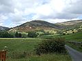 Looking north up Longsleddale
 -
 The small parish church of St Mary, Longsleddale
 -
 The Track up to Harter Fell, the River Sprint runs down the valley to the left of the track
 -
 Longsleddale. Looking north-east from the bridleway to Staveley, across the valley to Swinklebank.
 -
 Ubarrow Hall
 -
 Longsleddale, sun on Goat Scar


Outside links
- Location map: 54°25’8"N, 2°46’12"W
- Longsleddale Community
References
- ↑ National Monuments Record: No. 11732 – Ubarrow Hall
- ↑ Haweswater Aqueduct (Portsmouth University, Geography Department)
- ↑ The Haweswater Aqueduct under construction near Low House, Longsleddale, 1933 (photo) - Britain from Above
- ↑ Wainwright, Alfred: A Pictorial Guide to the Lakeland Fells, Book Two — The Far Eastern Fells (1957)
- ↑ Haweswater Aqueduct - Engineering Timelines
- ↑ Joy, David: 'Main Line Over Shap: the story of the Lancaster-Carlisle Railway' Dalesman 1968 (page 14)
- ↑ Postman Pat' BBC Magazine content 30 March 2006