Knotting
| Knotting | |
| Bedfordshire | |
|---|---|
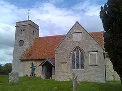
 St Margaret's Church | |
| Location | |
| Grid reference: | TL001136 |
| Location: | 52°15’0"N, -0°31’60"W |
| Data | |
| Post town: | Bedford |
| Postcode: | MK44 |
| Dialling code: | 01234 |
| Local Government | |
| Council: | Bedford |
| Parliamentary constituency: |
North East Bedfordshire |
Knotting is a small village and ancient parish in the Stodden Hundred of Bedfordshire, adjacent to the border with Northamptonshire. Nearby places are, Sharnbrook, Podington, Odell, Melchbourne, Yielden, Newton Bromswold, Souldrop and Rushden over the border in Northamptonshire.
Population
The parish was covered by the 2001 UK Census but was combined with neighbouring Souldrop. In 2001, there was a combined population of 269 people - in 110 households.[1] In 1831, there were just 135 inhabitants of Knotting alone, therefore it is possible that the population has not really altered.[2]
It has formed part of the civil parish of Knotting and Souldrop since 1934.
Parish church
The Parish Church is partly of 12th-century Norman construction, including a chancel arch with carved decoration, and is dedicated to St Margaret.[3] The registers date from 1592[4] and many of these are deposited at the Bedfordshire and Luton Archives and Records Service. The church was vested with the Churches Conservation Trust on 1 April 2009.[5]
References
- ↑ Office for National Statistics - 2001 Census
- ↑ A Topographical Dictionary of England - Samuel Lewis - 1831
- ↑ "Corpus of Romanesque Sculpture in Britain and Ireland". http://www.crsbi.ac.uk/search/county/site/ed-bd-knott.html.
- ↑ Kelly's Directory (1898)
- ↑ "Archived copy". http://www.visitchurches.org.uk/content.php?nID=115&newsID=31.
Outside links
| ("Wikimedia Commons" has material about Knotting) |

This Bedfordshire article is a stub: help to improve Wikishire by building it up.
