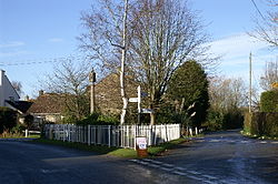
Kingston Seymour
| Kingston Seymour | |
| Somerset | |
|---|---|
 The Triangle, Kingston Seymour | |
| Location | |
| Grid reference: | ST402670 |
| Location: | 51°23’54"N, 2°51’38"W |
| Data | |
| Population: | 388 (2011) |
| Post town: | Clevedon |
| Postcode: | BS21 |
| Dialling code: | 01934 |
| Local Government | |
| Council: | North Somerset |
| Parliamentary constituency: |
North Somerset |
Kingston Seymour is a tiny village in Somerset with a population of 388. It is located in the county's northern region between Clevedon and Weston-super-Mare on the North Somerset Levels. It is part of the Chewton Hundred parish. The town is relatively near the M5 motorway.
History
On "The Triangle," a late mediaeval village cross is still visible.[1]
The church at Kingston Seymour reportedly had five feet of water within it for 10 days during the Bristol Channel floods of 1607 when the sea defences were overwhelmed.[2] The parish, which reaches the coast of the Severn Estuary, saw frequent floods as recently as the 1800s. Following flooding, the area was deemed unfit for dairy cattle for a while, and the poor air that resulted was believed to give locals "attacks of the ague."[3]
In 1858, Kingston Seymour School first welcomed students. After it closed in 1968, the structure served as the local drainage board's office before becoming a spinning and weaving centre. It is currently being used as a private residence.[4]
The settlement was once located along the Clevedon branch line, a railroad that connected Yatton station and Clevedon over a distance of 3.5 miles (5.6 km). Passenger services ended there in 1966 after it opened in 1847. In the late 1980s, the remaining original rail segments were removed from the area surrounding Kingston Seymour.
Geography
The settlement is adjacent to Blake's Pools, a nature reserve on the banks of the Congresbury Yeo near its mouth that is owned by the Environment Agency and leased by the Avon Wildlife Trust. In order to draw animals, the three freshwater and brackish lakes were created between 1983 and 1987. It is a component of the RAMSAR site, Special Protection Area, and Severn Estuary Site of Special Scientific Interest.
Parish church
The Church of All Saints, the parish church, was built in the Perpendicular Gothic architectural style in the late 14th or early 15th century. A noticeboard in the porch provides information on the Bristol Channel floods that struck this part of coastal Somerset in 1607. Floodwaters from that incident flooded the church's font and surged above the benches.
The church is now a Grade I listed structure.[5]
Outside links
| ("Wikimedia Commons" has material about Kingston Seymour) |
- Kingston Seymour at the Open Directory Project
- Yatton Moor Team Ministry
References
- ↑ National Heritage List 1320994: Village Cross
- ↑ Havinden, Michael (1982). The Somerset Landscape. The making of the English landscape. London: Hodder and Stoughton. pp. 159. ISBN 0-340-20116-9.
- ↑ Rutter, John (1829). Delineations of the North Western Division of the County of Somerset. author...London: Longman, Rees, and Company and J. and A. Arch, Cornhill. pp. 64. https://archive.org/details/delineationsnor00rowbgoog. "kingston seymour"
- ↑ Pudner, Marion; Sue Thomas (2008). Kingston Seymour School: The Root of Village Life 1858-1968. J.R. Marketing. ISBN 978-0-9540430-2-5.
- ↑ National Heritage List 1313027: Church of All Saints