Hargrave, Northamptonshire
| Hargrave | |
| Northamptonshire | |
|---|---|
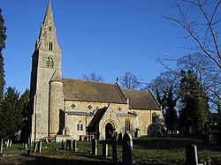
 All Hallows Church | |
| Location | |
| Location: | 52°19’26"N, 0°28’48"W |
| Data | |
| Population: | 241 (2011) |
| Post town: | Wellingborough |
| Postcode: | NN9 |
| Dialling code: | 01933 |
| Local Government | |
| Council: | North Northamptonshire |
| Parliamentary constituency: |
Corby |
Hargrave is a small village and parish situated in the Higham Ferrers Hundred of Northamptonshire, approximately 21 miles east of Northampton and adjacent to the borders with Bedfordshire and Huntingdonshire. At the time of the 2001 census, the parish's population was 236 people,.[1] increasing to 241 at the 2011 census.[2]
The 12th-century All Hallows Church is at the centre of the village. The village has a village hall with several active societies.
In 2007, Hargrave, Raunds, Ringstead and Stanwick were legally united as "The 4 Spires Benefice", with each village retaining its own church.[3]
Heritage assets
The following buildings and structures are listed by Historic England as of special architectural or historic interest.[4]
- Church of All Saints and chest tomb (Grade II*) 12th century
- Stone coffin, Church of All Saints (Grade II) 13th century
- Churchlands (Grade II) 17th century
- Wildacre (Grade II) 17th century
- Pair of chest tombs (Grade II) 17th century
- Nag's Head public house (Grade II) 17th century
- Box Tree Cottage and attached house (Grade II) 17th century
- Group of three chest tombs (Grade II) 18th century
- Hillstone Cottage (Grade II) 18th century
- War memorial (Grade II) 20th century
Geography
Ringstead, Keyston, Stanwick, Rushden, Higham Ferrers, Thrapston, Raunds, Wellingborough, Chelveston and Irthlingborough are places near Hargrave.
Demography
- In 1801 there were 158 persons[5]
- In 1831 there were 203 persons[5]
- In 1841 there were 257 persons[5]
- In 2001 there were 236 persons[6]
- In 2011 there were 241 persons[6]
References
| ("Wikimedia Commons" has material about Hargrave, Northamptonshire) |
- ↑ Office for National Statistics: Hargrave CP: Parish headcounts. Retrieved 12 November 2009
- ↑ "Civil Parish population 2011". Neighbourhood Statistics. Office for National Statistics. http://www.neighbourhood.statistics.gov.uk/dissemination/LeadKeyFigures.do?a=7&b=11124234&c=Hargrave&d=16&e=62&g=6451306&i=1001x1003x1032x1004&m=0&r=1&s=1467656609988&enc=1. Retrieved 4 July 2016.
- ↑ "4 Spires Benefice". http://4spires.org/. Retrieved 2015-09-11.
- ↑ National Heritage List for England (Historic England)
- ↑ 5.0 5.1 5.2 William Whellan & Co. (1849). History, Gazetteer and Directory Northamptonshire. Whittaker & Co.. pp. 885.
- ↑ 6.0 6.1 Office for National Statistics
This Northamptonshire article is a stub: help to improve Wikishire by building it up.