Gatehead
- Not to be confused with Gateshead
| Gatehead | |
| Ayrshire | |
|---|---|
| Location | |
| Grid reference: | NS393364 |
| Location: | 55°35’44"N, 4°32’55"W |
| Data | |
| Post town: | Kilmarnock |
| Postcode: | KA2 |
| Dialling code: | 01563 |
| Local Government | |
| Council: | East Ayrshire |
| Parliamentary constituency: |
Kilmarnock and Loudoun |
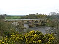
Gatehead is a hamlet in Ayrshire, belonging to the Parish of Kilmaurs. It is a mile and a quarter from Crosshouse and one and a half miles from Kilmarnock. In the 18th and 19th centuries the locality was a busy coal mining district. The settlement runs down to the River Irvine where a ford and later a bridge was located.
Background
Gatehead is an old colliers' village.[1] It stands at or near the junction of several roads, namely the main road to Kilmarnock, Dundonald and Troon, while nearby are other roads that run to Symington or Kilmarnock by way of Old Rome and Earlston, another to Springside or Crosshouse by way of Craig and yet another to Crosshouse, branching off the main Kilmarnock road. The village developed to cater for travellers on these roads and from the railway which was used also by carts and pedestrians as a 'toll' road or tramway before 1846.
The local shop and post office next to the old station have now closed.
History

Gatehead is most likely to have been named after the Turnpike road and the toll bar or gate. A 'Gatehead Toll Bar' is still marked nearby on the road to Laigh Milton mill and the Craig House estate as late as 1860 on the Ordnance Survey map of that year. 'Gatehead' is apparently first recorded marked on General Roy's Military Survey map of Scotland (1745–55) and then by Armstrong's 1775 map.[2] The toll house stood at NS38983670.
Archibald Adamson records a walk through Old Rome and Gatehead in 1875.[3] He mentions a neat lodge house at Fairlie, then owned by a Captain Tait and records that the Irvine bridge has recently replaced an older one. The Old Rome miners' cottages are in ruins following the local coal pits being worked out and the distillery ruins are still apparent. He goes on to say that Gatehead was established around fifty years back, (which would be around 1825), and in his day had neither kirk, smithy, mill or market, but a station.
Laigh Milton viaduct over the River Irvine stands nearby. This is the oldest railway viaduct north of the Solway,[4] and one of the oldest in the world.
The Cochrane Inn is likely to have originally been a coaching inn, serving the stagecoach route from Kilmarnock to Troon and Ayr. A milestone near the Crosshouse junction on the main road in 1860 gave Troon as 7 miles and Dundonald as 2Template:Fraction miles and another near the junction for Laigh Milton Mill gave Ayr as 10 miles and Kilmarnock as 2Template:Fraction miles.
A hamlet called 'Milton' is marked on the 1821 and 1828 maps,[5][6] but the name is not marked on the 1860 and the more recent OS maps. Laigh Milton mill still stands, but is now in a ruinous condition (2007). A laithe or saw mill existed across the river from Craig House, which had its own mill and a ford, together with another mill near Drybridge at 'Girtrig' or previously 'Greatrig'.

A 'Romford', 'Rameford', 'Room' or 'Rome Ford' was situated where the modern road bridge crossing the River Irvine is located. In Scots 'Rommle' is to rumble or stir violently,[7] a more likely explanation than some memory of the Roman occupation of Scotland. Another suggestion is that 'Room' or 'Rome' in Scots meant a small farm.[7][8] Both Thomson[6] and Ainslie[5] show the railway apparently branching and crossing the Irvine by means of a bridge near to the ford and this branch or mineral line halting near Fairlie House on Thomson's map and carrying on towards Symington on Ainslie's map. This branch may never have been built, shown due to its planned, but not executed, construction.
The railway level crossing has been here[5] since the Kilmarnock and Troon Railway opened in 1811,[9] but as stated, the name 'Gatehead' predates the railway. A stable was located hereabouts and the horses pulling the wagons were changed here.[10] Gatehead railway station closed in 1967, having opened with the rest of the line on 6 July 1812.
A distillery once existed near Old Rome,[3] although no signs of its existence are now visible. A smithy existed, as marked on the 1880s OS. It was on the left-hand side, just across the bridge from Old Rome. A school existed at Old Rome that may also have been used by pupils from Gatehead.
Estates

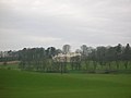
Gatehead was surrounded by several country estates which provided employment and helped create the need for the establishment of settlements such as Old Rome and Gatehead. The Craig estate of the Dunlops and more recently the Pollok-Morris's, lying within the ancient Barony of Robertoun, lay just beyond Laigh Milton Mill and the Fairlie estate is just across the River Irvine. Capringtoun, a Cunninghame clan estate is nearby and Thorntoun and Carmel Bank (previously known as Mote or Moit in 1604),[11] previously another Cunninghame property lies near Springside. Craig House was at one point sold to Glasgow Corporation as a 'respite home' for mainly Glaswegian children,[12] it became a ruin after the 'school' closed, however it has since been fully restored and converted into flats.
Fairlie was locally termed "Fairlie o' the five lums" according to Adamson in 1875,[13] on account of the five large chimneys in a row along the roof ridge of the mansion.[14] Fairlie had been known as 'Little Dreghorn', until William Fairlie of Bruntsfield gave it his family name in around 1704.[15] Robert Gordon's manuscript map of ca. 1636 – 52 indicates a small mansion at 'Little Drogarn',[16] and it has been suggested by McNaught that the woodland here was locally known as 'Old Rome Forest' at this time.[17] The 'Laird of Fairlie' also owned Arrothill. Sir William Cunninghame of Fairlie and Robertland is recorded by George Robertson in 1823 as living "in a shewy modern mansion",[18] i.e. Fairlie. A mineral spring known as 'Spiers Well' existed near Gatehead in 1789.[19]
At the time of Alexander Fairlie one of his estate workers, Josey Smith,[20] composed the following lines :-
On the green banks of Irvine lives Fairlie of Fairlie,
Who oft speaks of good things, and does them but rarely.
Lord Eglinton's tenants they walk very barely,
Being robbed of their riches by Fairlie of Fairlie.
It's in the low regions, oh! how he will fret,
When there is no farming or farms for to set.
The Devil and him they will scold it right sairly,
And Hell will resound with the shrieks of auld Fairlie.
The Barony of Robertoun
This barony, once part of the Barony of Kilmaurs, ran from Kilmaurs south to the river Irvine. It had no manor house and belonged to the Eglinton family latterly. The following properties were part of the barony: Gatehead, parts of Kilmaurs, Craig, Woodhills, Greenhill, Altonhill, Plann, Hayside, Thorntoun, Rash-hill Park, Milton, Windyedge, Fardelhill, Muirfields, Corsehouse and Knockentiber and Busbie.[19]
Robert Burns
Robert Burns' father worked on the Fairlie Estate as a gardener for a time.[21] Old Rome Forest or Old Room Ford was a house in the Fairlie estate where Jean Brown, an aunt of Burns on his mother's side, lived with her husband, James Allan. When Burns had to go into hiding as a result of James Armour's warrant for his arrest, the poet stayed at his aunt's house. Nothing remains of Old Rome Forest, but according to Duncan M'Naught, (in an article in the Burns Chronicle, 1893) the house was on the Fairlie estate.[22] McNaught states that Fairlie House was called 'Old Rome Forest' in his day.
Collieries and Coal Pits
A colliery railway ran in from the Kilmarnock and Troon 'main line' near Gateside to coal works belonging to Sir William Cuninghame of Robertland Bart. The length of the branch was four furlongs and one hundred and seven yards nearly. The line crossed the river downstream of the Romeford bridge.[23] Other mineral lines ran to collieries near Earlston, Nether Craig and Cockhill farm (Fairlie (Pit No.3)). The bridges built for these lines are still clearly visible with the exception of the wooden bridge crossing the river near the original stone viaduct.
Cholera
In 1832 an outbreak of Cholera claimed many lives in Kilmaurs and to prevent the entrance of strangers or vagrants, guards were placed at Gatehead, Knockentiber and other places to prevent any communication between the occupants of Kilmaurs and the rest of the community.[24]
Pictures
-
 Gatehead station which opened in 1812 and closed on 3 March 1969.
 -
 A coal train from the 'Troon' end of the line.
 -
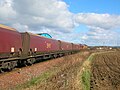 A coal train heading up to Kilmarnock.
 -
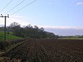
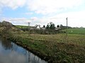
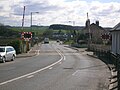 Looking towards the River Irvine, Old Rome and the Fairlie estate.
 -
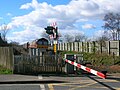
 Looking towards the Cochrane Inn from the level crossing, the old post office and shop on the left.
 -
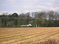
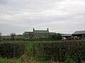 West Gatehead farm. 2007. A track ran from here to Fairlie Pit No.3 across the Laigh Milton viaduct.
 -
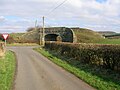
 Laigh Milton viaduct, looking towards the old waste bings of Fairlie Colliery (Pit No.3).
 -
 Craig House from Laigh Milton viaduct.
 -
 Laigh Milton Mill.
 -
 The lodge house and gates at Fairlie House.
 -
 The woodland policies and Fairlieholm from Gatehead.
 -
 Old Rome from Gatehead's bridge over the Irvine.
 -
 The old railway bridge at Templeton on the G&SWR.s Fairlie branch.


Outside links
| ("Wikimedia Commons" has material about Gatehead) |
- Video and commentary on Old Rome and Gatehead.
- Maps at the National Library of Scotland.
- 1860 OS Maps.
- General Roy's Military Survey map of Scotland.
References
- ↑ Groome, Francis H. (1903). Ordnance Gazetteer of Scotland. Pub. Caxton. London. P. 643.
- ↑ Armstrong and Son. Engraved by S.Pyle (1775). A New Map of Ayr Shire comprehending Kyle, Cunningham and Carrick.
- ↑ 3.0 3.1 Adamson, Archibald R. (1875). Rambles Round Kilmarnock. Pub. Kilmarnock. Pps. 93 – 94.
- ↑ East Ayrshire Tourism
- ↑ 5.0 5.1 5.2 Ainslie, John (1821). A Map of the Southern Part of Scotland.
- ↑ 6.0 6.1 Thomson, John (1828). A Map of the Northern Part of Ayrshire.
- ↑ 7.0 7.1 Warrack, Alexander (1982)."Chambers Scots Dictionary". Chambers. ISBN 0-550-11801-2.
- ↑ 'Room' or 'Rome'
- ↑ Awdry, Christopher, (1990). Encyclopaedia of British Railway Companies. London: Guild Publishing.
- ↑ Mackintosh, Ian M. (1969), Old Troon and District. Pub. George Outram, Kilmarnock. P. 43.
- ↑ Pont, Timothy (1604). Cuninghamia. Pub. Blaeu in 1654.
- ↑ Strawhorn, John and Boyd, William (1951). The Third Statistical Account of Scotland. Ayrshire. Pub. P. 475
- ↑ Adamson, Archibald R. (1875). Rambles Round Kilmarnock. Pub. Kilmarnock. P.93.
- ↑ Millar, A. H. (1885).Which in more recent times was shortened to "Fairlie Five Lums" by local people . The Castles & Mansions of Ayrshire. Reprinted The Grimsay Press. ISBN 1-84530-019-X. P. 78
- ↑ Paterson, James (1863–66). History of the Counties of Ayr and Wigton. V.II. – Part II – Kyle. J. Stillie. Edinburgh. P. 477.
- ↑ Gordon, Robert (1636–52). Cuningham. Manuscript map held by the NLS.
- ↑ *McNaught, Duncan (1912). Kilmaurs Parish and Burgh. Pub. A.Gardner.
- ↑ Robertson, George (1823). A Genealogical Account of the Principal Families in Ayrshire. Pub. A.Constable, Irvine. P. 330
- ↑ 19.0 19.1 National Archives of Scotland. RHP3 / 37.
- ↑ Strawhorn, John (1995). The Scotland of Robert Burns. Darvel : Alloway Publishing. ISBN 0-907526-67-5. P. 56.
- ↑ Private Burns
- ↑ Old Rome Forest
- ↑ Mackintosh, Ian M. (1969), Old Troon and District. Pub. George Outram, Kilmarnock. Map facing p. 48.
- ↑ *McNaught, Duncan (1912). Kilmaurs Parish and Burgh. Pub. A.Gardner. P. 254.