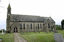
Dalton, Thirsk
| Dalton | |
| Yorkshire North Riding | |
|---|---|
 Church of St John the Evangelist, Dalton | |
| Location | |
| Grid reference: | SE434763 |
| Location: | 54°10’51"N, 1°20’8"W |
| Data | |
| Population: | 518 (2011) |
| Post town: | Thirsk |
| Postcode: | YO7 |
| Dialling code: | 01845 |
| Local Government | |
| Council: | North Yorkshire |
Dalton is a village in the North Riding of Yorkshire, standing four miles to the south of Thirsk, near the A168 road. The parish mainly consists of farmland as well as an industrial estate. It has a population of 518.
History

The name of the village is first recorded as Deltone in the Domesday Book of 1086. The name is derived from the Old English dæl tun, meaning "valley settlement".[1]
Dalton had just ten households in 1066, which is quite a small amount in comparison to other parishes according to the Domesday Book. The total tax assessed is 5.2 geld units, which is quite large for a parish. The Lord in 1066 was called Bernwulf and the value to the lord was £4. The Lord as well as tenant-in-chief in 1086 was William of Percy and the value was £5. Dalton had 15 ploughlands, one mill, one church and four furlongs worth of woodland.[2]
In 1086 Dalton was a berewick (outlying estate) of Topcliffe, and by the 15th century was known as a manor. Until the 19th century it remained a township of the large ancient parish of Topcliffe in the wapentake of Birdforth.[3]
In 1870, John Marius Wilson recorded:[4]
Dalton, a township in Topcliffe parish, N. R. Yorkshire; on the Great North of England railway, 4¼ miles S of Thirsk. Acres, 1, 247. Real property, £1, 709. Pop., 307. Houses, 77. There are chapels for Wesleyans and Primitive Methodists.
During the Second World War, RAF Dalton was used as an airfield by RAF Bomber Command. It was home to No.102 Squadron in November 1941. In 1943 it was allocated to No.6 Group Royal Canadian Air Force (RCAF).[5]
Outside links
| ("Wikimedia Commons" has material about Dalton, Thirsk) |
References
- ↑ The Cambridge Dictionary of English Place-Names; ISBN 9780521168557
- ↑ Dalton, Thirsk in the Domesday Book
- ↑ National Heritage List 2: Parishes: Topcliffe
- ↑ Wilson, John (1870–72). Gazetteer of the British Isles (1st ed.). Edinburgh: Bartholomew. http://www.visionofbritain.org.uk/place/place_page.jsp?p_id=12261#. Retrieved 4 February 2013.
- ↑ Delve, Ken (2006). Northern England : Co. Durham, Cumbria, Isle of Man, Lancashire, Merseyside, Manchester, Northumberland, Tyne & Wear, Yorkshire. Ramsbury: Crowood. pp. 96–98. ISBN 1-86126-809-2.