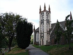
Dalry, Kirkcudbrightshire

Dalry is a parish in northern Kirkcudbrightshire adjacent to the borders with Dumfriesshire and Ayrshire. It is situated 15 miles north of Castle Douglas by the A713 road. Its name signifies the "Royal Dale". The parish rises from a level and fertile plain called the Holm where St John's Town of Dalry is to be found, to a more mountainous aspect to the north. It is about fifteen miles in length, and seven miles in breadth, comprising over 34,000 acres. Surrounding parishes clockwise from the north are New Cumnock in Ayrshire, Sanquhar, Penpont, Tynron and Glencairn in Dumfriesshire and Balmaclellan, Kells and Carsphairn in its own county.
The Water of Ken, which rises in the northern extremity of the parish, forms the western boundary between it and Kells and, after a beautifully winding course, flows through Loch Ken into the River Dee. The smaller streams are, the Blackwater, the Earlston and the Stronriggan, which run through the parish into the Ken. They all abound with trout, and in the Ken are found also pike and salmon. The chief lakes are Lochinvar, Boston, Knocksting and Knockman, of which Lochiavar, about fifty acres in extent, is the most important. In Lochinvar are the remains of the ancient castle of the Gordons, knights of Lochinvar, and afterwards viscounts Kenmure and near it is a cairn, raised as a trophy on a spot where the first knight killed a wild boar that infested this part of the country. The scenery along the banks of the Ken is enriched with ancient woods, of which the largest is that of Earlston, formerly a hunting seat of the Earl of Bothwell.
This Kirkcudbrightshire article is a stub: help to improve Wikishire by building it up.