Crofton, Kent
| Crofton | |
| Kent | |
|---|---|
 Crofton | |
| Location | |
| Grid reference: | TQ445658 |
| Location: | 51°22’20"N, -0°4’26"E |
| Data | |
| Population: | 14,632 (2011) |
| Post town: | Orpington |
| Postcode: | BR5, BR6 |
| Local Government | |
| Council: | Bromley |
| Parliamentary constituency: |
Orpington |
Crofton is village in Kent, which has become effectively a suburb of Orpington. It stands within the metropoian conurbation, to the south of Petts Wood, west of Orpington and Broom Hill, north of Green Street Green and Farnborough, north-east of Locksbottom and east of Bromley Common.
History

A Roman settlement existed here from circa 140 ADs-400: the ruins of a Roman villa form a small museum just next to Orpington train station.[1]
The name 'Crofton' comes from Old English and indicates a 'farm on a rounded hill'.[1] Little is known of its subsequent history, though it remained a rural locality until well into the 19th century.[1] Some small-scale development occurred from 1868 following the opening of Orpington train station, and St Paul's Church, Crofton Road was built in 1887 (later rebuilt in 1958).[1] The inter-war years saw extensive development and the area is now effectively a suburban extension of Orpington.[1]
About the village
The area contains two small shopping parades on Crofton Lane and Kelvin Parade. To the north-west lies Crofton Wood, which is designated a Site of Special Scientific Interest.[1][2]
Pictures
-
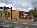
 Shops on Crofton Lane
 -
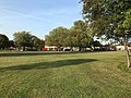 Oregon Square Open Space, with the Kelvin Parade shops at the far end
 -
![St Paul's Church, built in 1958 by AB Knapp-Fisher[3]](https://upload.wikimedia.org/wikipedia/commons/thumb/d/d6/St_Paul%27s_Church%2C_Crofton.jpg/120px-St_Paul%27s_Church%2C_Crofton.jpg) St Paul's Church, built in 1958 by AB Knapp-Fisher[3]
St Paul's Church, built in 1958 by AB Knapp-Fisher[3] -
 Crofton village sign
 -
 Crofton War Memorial at St Paul's Church
 -
 Crofton Roman Villa Museum


![St Paul's Church, built in 1958 by AB Knapp-Fisher[3]](/wiki/File:St_Paul%27s_Church,_Crofton.jpg)


References
- ↑ 1.0 1.1 1.2 1.3 1.4 1.5 Willey, Russ (2006). The London Gazetteer. Chambers Harrap Publishers Ltd. pp. 125–6.
- ↑ SSSI listing and designation for Crofton Woods
- ↑ "St Paul's Church, Crofton, Kent". London Churches in Photographs (London Church Buildings). 23 February 2017. https://londonchurchbuildings.com/2017/02/23/st-paul-crofton-lane-crofton/. Retrieved 12 September 2020.