Cotmanhay
Jump to navigation
Jump to search
| Cotmanhay | |
| Derbyshire | |
|---|---|
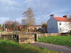
 Cotmanhay linear park | |
| Location | |
| Grid reference: | SK465430 |
| Location: | 52°58’58"N, 1°18’31"W |
| Data | |
| Population: | 4,530 (2011) |
| Post town: | Ilkeston |
| Postcode: | DE7 |
| Local Government | |
| Council: | Erewash |
| Parliamentary constituency: |
Erewash |
Cotmanhay is a village in Derbyshire, in the east of the county, north of Ilkeston. The population at the 2011 Census was recorded as 4,531.
The neighbourhood's two main industries were textiles and coal mining, the latter from 1848 until 1880.
The 2019 Multiple deprivation index found the area around Skeavingtons Lane to be the most deprived area in Derbyshire.[1][2]
Outside links
| ("Wikimedia Commons" has material about Cotmanhay) |
References
- ↑ Miller, Claire; Sutherland, Rachel (27 October 2019). "Allenton and Derwent among 'most deprived neighbourhoods' in England". Derbyshire Live. https://www.derbytelegraph.co.uk/news/derby-news/most-deprived-neighbourhoods-derbyshire-3367576.
- ↑ Sutherland, Rachel (16 December 2019). "This is what residents really think of 'most deprived' streets in Derbyshire". Derbyshire Live. https://www.derbytelegraph.co.uk/news/derby-news/what-residents-thought-derbyshires-most-3635877.