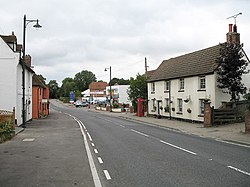
Colliers End
Jump to navigation
Jump to search
| Colliers End | |
| Hertfordshire | |
|---|---|
 Colliers End | |
| Location | |
| Grid reference: | TL371206 |
| Location: | 51°52’3"N, 0°-0’36"W |
| Data | |
| Postcode: | SG11 |
| Local Government | |
| Council: | East Hertfordshire |
Colliers End is a little village north of Ware, on the local road going on to Puckeridge. Standon Green End just to the south.
The village stands at the meeting of two Roman roads, of which one is Ermine Street, which route serves today as the main road through the village. The route of Ermine Street became the old Great Cambridge Road in latter days but it has been superseded by the A10, which runs parallel to the east, allowing Colliers End some peace from through traffic.
This Hertfordshire article is a stub: help to improve Wikishire by building it up.