Chew Green
| Chew Green Latin: Ad Fines | |
| Northumberland | |
|---|---|
 Chew Green Roman camp | |
| Type: | Roman camp |
| Location | |
| Grid reference: | NT787086 |
| Location: | 55°22’16"N, 2°20’13"W |
| History | |
| Information | |
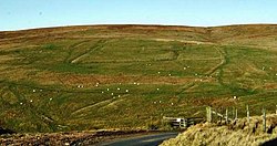
Chew Green is the site of the ancient Roman encampment high amongst the Cheviot fells of Northumberland, close to the bounds of Roxburghshire. It is commonly, but apparently erroneously, called Ad Fines ('The Limits') as that is the name given on the 1885-1900 edition of the Ordnance Survey map,[1], England,[2] The site is found eight miles north of Rochester and nine miles west of Alwinton. The encampment was adjacent to Dere Street, a Roman road that stretched south to York (Eboracum), and towards Edinburgh.
Archaeological excavation at Chew Green has uncovered a complex of Roman military camps consisting of a Roman fort, two fortlets, two camps and a section of Roman road. The Roman remains were overlaid with evidence of the mediæval settlement of Kemylpethe[3] that included a small chapel, although the evidence for this latter is based on reports of an undocumented excavation in the 1880s and must be regarded as insubstantial. The largest camp structure is a square that encloses about 17 acres, with a defensive rampart and ditch. Evidence inside the fort indicates it was used as permanent settlement. The encampment likely served only as a military base, not a settlement.[4]
The site is within the Northumberland National Park and within the Military Training Area at Otterburn.
See also
Outside links
| ("Wikimedia Commons" has material about Chew Green) |
References
- ↑ Ad Fines Camps, OS One Inch, 1885-1900, NLS
- ↑ Richmond, I.A., & Keeney, G.S. (1937). Archaeologia Aeliana (4th Series) 14, 129–50.
- ↑ Kemylpethe, NLS
- ↑ Stuart, R. (1845). Caledonia Romana: A Descriptive Account of the Roman Antiquities of Scotland. London, UK: Bell and Bradfute.