Broxbourne
| Broxbourne | |
| Hertfordshire | |
|---|---|
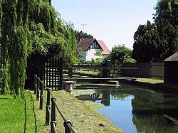
 The New River at Broxbourne | |
| Location | |
| Grid reference: | TL365075 |
| Location: | 51°44’58"N, 0°1’18"W |
| Data | |
| Population: | 13,298 |
| Post town: | Broxbourne |
| Postcode: | EN10 |
| Dialling code: | 01992 |
| Local Government | |
| Council: | Broxbourne |
| Parliamentary constituency: |
Broxbourne |
Broxbourne is a commuter town in south-eastern Hertfordshire; a town of 13,298 in 2001. It is within the long conurbation along the west side of the River Lea, reaching from the London metropolis itself up to Hoddesdon and its suburbs.
Broxbourne is about a mile north of Wormley and south of Hoddesdon. The town is near to the River Lea which here forms the boundary with Essex and is 4½ miles north of the M25 motorway. West of the town are Broxbourne Woods, a National Nature Reserve.[1]
The Greenwich Meridian passes to the east of Broxbourne.
History
Broxbourne grew up on the Great Cambridge Road, now known as the A10. A number of old houses and inns dating from the 16th to the 19th century still line the High Street (now the A1170).[2] The Manor of Broxbourne is described in the Domesday Book, which mentions Broxbourne Mill. The manor was held in the time of Edward the Confessor by Stigand, the Archbishop of Canterbury, but had passed into Norman hands following the Conquest. King John granted the manor to the Knights Hospitallers, who held it until the Dissolution, when it passed to John Cock, after whose family Cock Lane is named.[3]
The parish church of St Augustine was entirely rebuilt in the 15th century, although a 12th-century Purbeck marble font survives. The interior has a number of monuments and brasses dating from the 15th to the 19th century. The three stage tower has a belfry with a peal of eight bells, three of which are dated 1615.[4]
The New River which passes through the centre of the town, was constructed in the early 17th century. Broxbourne railway station was built in 1840. A terracotta works was opened soon afterwards[5] by James Pulham and Son, who specialised in creating artificial rock garden features; some of their work survives in the gardens at Sandringham House and Buckingham Palace.[6]

Sport and leisure
- Football (non-league):
- Broxbourne Borough V&EFC
- London Lions FC
2012 Summer Olympics
As part of the London 2012 Summer Olympics, Spitalbrook was chosen as the venue for whitewater canoe and kayak slalom events. On 8 October 2007 the Olympic Delivery Authority (ODA) announced that due to contamination risks at the planned Spitalbrook site, an alternative site six miles south was being investigated.[7]
Subsequently on 16 April 2008 it was announced that the venue would be built at nearby Waltham Cross and situated on what was (at the time of the relevant press release) the overflow car park for the showground at the River Lee Country Park.[8] The venue was initially known as Broxbourne White Water Canoe Centre and later officially named Lee Valley White Water Centre.[9]
In September 2011, the course was blessed by the Bishop of Hertford, who was taken the 5½ miles down the white water slalom course.[10]
Outside links
- ↑ http://www.naturalengland.org.uk/ourwork/conservation/designatedareas/nnr/1005000.aspx
- ↑ http://www.british-history.ac.uk/report.aspx?compid=43639
- ↑ http://www.british-history.ac.uk/report.aspx?compid=43639#s3
- ↑ http://www.british-history.ac.uk/report.aspx?compid=43639#s16
- ↑ http://www.albury-field.demon.co.uk/bxind.htm
- ↑ http://www.parksandgardens.ac.uk/index2.php?option=com_content&task=view&id=336&pop=1&page=5&Itemid=1
- ↑ Olympic Delivery Authority update
- ↑ New Canoeing venue in Broxbourne confirmed for the London 2012 Olympic Games London2012.com Press Release, 16 April 2008
- ↑ London2012.com venue page
- ↑ Bishop and Archdeacon ride the rapids – Diocese of St Albans news
References
| ("Wikimedia Commons" has material about Broxbourne) |