Bobbington
| Bobbington | |
| Staffordshire | |
|---|---|
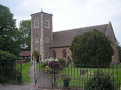
 Holy Cross church | |
| Location | |
| Grid reference: | SO809905 |
| Location: | 52°30’44"N, 2°16’58"W |
| Data | |
| Population: | 588 (2011)[1]) |
| Post town: | Stourbridge |
| Postcode: | DY7 |
| Dialling code: | 01384 |
| Local Government | |
| Council: | South Staffordshire |
Bobbington is a village and parish in Staffordshire, about five miles west of Wombourne, and eight miles east of Bridgnorth in Shropshire. According to the 2001 census it had a population of 506, increasing to 588 at the 2011 Census.
Bobbington is just on the county border with Shropshire to the west, and the parish extends into that county at Whittimere and Upper Whittimere farms.
Holy Cross parish church dates from the 12th century, and in 1878 it was restored by Sir Arthur Blomfield. The church is built in sandstone with tile roofs, and consists of a nave with a vestry, a north aisle with a vestry, a chancel, and a south-west tower. The tower has three stages, pilaster buttresses, a south doorway, dentilled eaves, and a pyramidal roof. The north arcade is Norman, with round arches, cylindrical columns and scalloped capitals.
During World War II the village was home to Bobbington airfield, renamed during the war as Halfpenny Green, and now known as Wolverhampton Halfpenny Green Airport.
In recent years Bobbington has seen favour in the commuter culture being roughly equidistant from many of the regions business centres Wolverhampton (9½ miles) Dudley (9½ miles), Stourbridge (10½ miles) and Bridgnorth (8½ miles).
Schools
- Corbett Primary School
References
Outside links
| ("Wikimedia Commons" has material about Bobbington) |
This Staffordshire article is a stub: help to improve Wikishire by building it up.