Billingborough
| Billingborough | |
| Lincolnshire | |
|---|---|
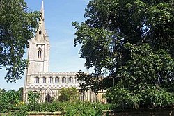
 Church of St Andrew, Billingborough | |
| Location | |
| Grid reference: | TF116342 |
| Location: | 52°53’37"N, 0°20’25"W |
| Data | |
| Population: | 1,401 (incl. Birthorpe. 2011) |
| Post town: | Sleaford |
| Postcode: | NG34 |
| Dialling code: | 01529 |
| Local Government | |
| Council: | South Kesteven |
| Parliamentary constituency: |
Grantham and Stamford |
Billingborough is a village in Kesteven, the south-western part of Lincolnshire, in the Aveland Wapentake, about ten miles north of Bourne and ten miles south of Sleaford. It is positioned at the edge of the Great Fen, on the B1177 road between Horbling and Pointon just south of the A52.
The 2001 census recorded a population of 1,401 in 591 households.
The name is from the Old English language, from Billinga burh, meaning '(fortified) town of Billa's folk'.
History
The area was populous in the Middle Ages, and included the lost village of Ouseby.[1] and shrunken village of Birthorpe.[2]
The village was formerly served by the Billingboro and Horbling railway station.[3]
Parish church
The parish church, St Andrew's, dates to the 13th century and is in a mixture of Perpendicular Gothic and Decorated styles.[4]
The parish is part of the Billingborough Group benefice.
About the village
The village public house is the Fortescue Arms on High Street. There is a post office in the village which is also a convenience store and a small supermarket.
Billingborough has a pre-school and a primary school[5] The village's Aveland High School merged in 2010 with a Sleaford school to form St George's Academy.[6]
Society
There is an Army Cadet Force detachment next to the St Georges Academy site. It is part of the Lincolnshire Army Cadet Force [7] and wears the cap badge of the Royal Engineers.
- Cricket: Billingborough Horbling and Threekingham Cricket Club.
Outside links
| ("Wikimedia Commons" has material about Billingborough) |
References
- ↑ National Monuments Record: No. 350961 – Ouseby
- ↑ National Monuments Record: No. 351023 – Birthorpe
- ↑ National Monuments Record: No. 498482 – Billingborough and Horbling station
- ↑ National Monuments Record: No. 350971 – Church of St Andrew
- ↑ "Billingborough Primary School". http://www.billingborough.lincs.sch.uk/.
- ↑ "St. George's Academy web site". http://www.st-georges-academy.org/.
- ↑ Lincolnshire ACF