Beckermet
| Beckermet | |
| Cumberland | |
|---|---|
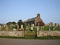
 St John's church in the village centre | |
| Location | |
| Grid reference: | NY018067 |
| Location: | 54°26’49"N, 3°30’54"W |
| Data | |
| Population: | 1,619 (2011) |
| Post town: | Beckermet |
| Postcode: | CA21 |
| Dialling code: | 01946 |
| Local Government | |
| Council: | Cumberland |
| Parliamentary constituency: |
Copeland |
Beckermet is a village in the west of Cumberland, located near the coast between Egremont and Seascale. It is served by Braystones railway station and is less than a mile west of the A595 road. The village is around two miles from the Sellafield nuclear power station, which may be seen from the higher parts of the village.
The name
The natural assumption is that the village is so named because two becks meet here, specifically Kirk Beck and Black Beck. However, the name is pronounced with the accent on the middle syllable (over the years, attempts by people to spell the name as they heard it have resulted in versions like Beck Armett in 1570, and Bekyremet in 1279). In the 12th century there was an 'h' in the middle, the earliest known version, from 1130, being Bechermet, so the English Place-Name Society suggests that the name really means "hermit's stream".

Churches
The two parishes
The village is divided between two parishes of the Church of England (which until 2011 was reflected in the organisation of civil parishes). The two parishes are:
- Beckermet St John to the north-west, which contains the bulk of the village; and
- Beckermet St Bridget to the south-east, now called the Parish of St Bridget, Beckermet and Ponsonby[1]
Arguably, a third parish should be included, as the parish of Haile (to the northeast) extended to within a few yards of St John's parish church, however this extension contains only fields
The St Bridget included most of the small village of Calder Bridge, and the hamlet of High Sella field, along with about half of the nuclear plant. A large portion of the population of St John lived in the former mining community of Thornhill, near Egremont.

Churches
- Parish of St John's, Beckermet:
- St John's
- Mission Church, Thornhill
- Parish of St Bridget, Beckermet and Ponsonby:
- St Bridget
- St Bridget, Old Church
- Ponsonby Church
The current Church of St Bridget, built in 1842, is at Calder Bridge, but the old "Low Church" about half a mile south of the village (NY015061), a plain building of Norman origin with 13th century modifications, is still used occasionally. In the churchyard are the remains of two ancient crosses, one of which has a runic inscription, of which several very contradictory translations have been made.
The church of St John, in the centre of the village, was rebuilt in 1878–79, but it too has fragments of ancient crosses, and many carved stone mediæval coffin lids. The ruined monastery of Calder Abbey is also within St Bridget's old parish.
Transport

Beckermet had a station on the Whitehaven, Cleator and Egremont Railway but it closed in 1947 and the nearest station now is Braystones on the coastal line a mile and a half from the village.
Castle sites
St John's parish also contains traces of two mediæval castles, probably both residences of the le Fleming family, who were granted land in the area shortly after the Norman conquest of the area. The earlier, at Wodobank near Thornhill, had a defensive motte and possibly an adjoining bailey enclosure. A railway line, itself now abandoned, obliterated most of the remains. The outline of the later fortification, known as Caernarvon Castle, can still be traced in the fields north of the village (NY021073); it was abandoned about 1250 when the family moved to Coniston. Although Caernarvon was identified as a castle site by a later member of the family, 17th century historian Sir Daniel Fleming, some experts believe it was never inhabited, and that its alternative name "Coneygarth Cop" may indicate that it was a mediæval rabbit warren.
Sights about the village
Calder Abbey, which lies by the River Calder just north of Calder Bridge, is a picturesque ruin adjoining Calder Abbey House, a largely 19th-century house which incorporates some remains of the abbey.
The village also houses an 18th-century coach house, this is now the White Mare public house.
To the south of Calder Bridge, also close to the river, is Sella Park, a 17th-century house incorporating a 14th-century pele tower, restored in the 19th century and now a country house hotel.[2]
Pictures
- More images
-
 St Bridget's Church, the old "low" church
 -
 Runic cross top- Lysons 1816
 -
 Runic cross top- Victoria History 1901
 -
 Runic cross back & sides
 -
 Interlace cross, St. Bridget's
 -
 The White Mare


Outside links
| ("Wikimedia Commons" has material about Beckermet) |
- Historical information on Beckermet St Bridget Vision of Britain- accessed 2008-02-25
- Pictures of old St. Bridget's church
- Pictures of later St. Bridget's church, Calder Bridge
- The cross stumps in St. Bridget's churchyard BBC Cumbria- accessed 2008-02-25
- Historical information on Beckermet St. John Vision of Britain- accessed 2008-02-25
- Pictures of St. John's church visitcumbria.com- accessed 2008-02-25
- The White Mare
References
- ↑ Beckermet on A Church Near You
- ↑ Sella Park - British Listed Buildings