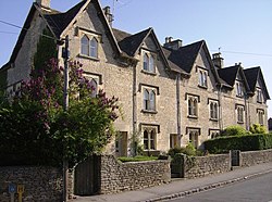
Avening
Jump to navigation
Jump to search
| Avening | |
| Gloucestershire | |
|---|---|

| |
| Location | |
| Grid reference: | ST883979 |
| Location: | 51°40’48"N, 2°10’9"W |
| Data | |
| Postcode: | GL8 |
| Local Government | |
| Council: | Cotswold |
| Parliamentary constituency: |
The Cotswolds |
Avening is a village and parish in the Longtree hundred of Gloucestershire, about three miles north of Tetbury. According to the 2001 census it had a population of 1,094, decreasing to 1,031 at the 2011 census.
Nearby stands Gatcombe Park, the home of the Princess Royal.
History
During the Second World War, Avening lay on GHQ Line. Extensive anti-tank ditches were constructed to the south and south-east, and were overlooked by a number of pillboxes. The defences were constructed as a part of British anti-invasion preparations.[1]
Parish church

The parish church is the Church of the Holy Cross, which was built in late 11th century. It is a Grade I listed building.[2]
[[File:Leaving Avening - geograph.org.uk - 488385.jpg
Outside links
| ("Wikimedia Commons" has material about Avening) |
- Avening Parish Council
- Avening in the Domesday Book
- Avening on Stroud Voices
References
- ↑ Foot, 2006, p 291-296.
- ↑ National Heritage List 1341564: Church of the Holy Cross
- Foot, William (2006). Beaches, fields, streets, and hills ... the anti-invasion landscapes of England, 1940. Council for British Archaeology. ISBN 1-902771-53-2.