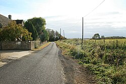
Weald, Oxfordshire
From Wikishire
Revision as of 13:28, 6 March 2024 by RB (Talk | contribs) (Created page with "{{Infobox town |name=Weald |county=Oxfordshire |picture=Road through Weald - geograph.org.uk - 1542015.jpg |picture caption= |os grid ref=SP308022 |latitude=51.718 |longitude=...")
| Weald | |
| Oxfordshire | |
|---|---|

| |
| Location | |
| Grid reference: | SP308022 |
| Location: | 51°43’5"N, 1°33’14"W |
| Data | |
| Post town: | Bampton |
| Postcode: | OX18 |
| Dialling code: | 01993 |
| Local Government | |
| Council: | West Oxfordshire |
| Parliamentary constituency: |
Witney |
Weald is a hamlet sitting half a mile south-west of Bampton in Oxfordshire. The name 'Weald' is from the Old English for "woodland".
The place is recorded by name in the late 12th century when Osney Abbey acquired a house there. It was a separate township by the 13th century. In the 18th and 19th centuries the township included much of the southwest part of the town of Bampton itself.
A large late 17th century manor house, Weald Manor, was remodelled at around 1730.[1] It is a Grade II* listed building.[2]
References
- ↑ Sherwood & Pevsner, 1974, page 433
- ↑ National Heritage List 1198982: Weald Manor
- A History of the County of Oxford - Volume 13 pp 60-62: Bampton and Weald: Charities for the poor (Victoria County History)
- Nikolaus Pevsner: The Buildings of England: Oxfordshire, 1974 Penguin Books ISBN 978-0-300-09639-2