Swarkestone
| Swarkestone | |
| Derbyshire | |
|---|---|
 Swarkestone Bridge | |
| Location | |
| Grid reference: | SK372286 |
| Location: | 52°51’11"N, 1°27’4"W |
| Data | |
| Post town: | Derby |
| Postcode: | DE73 |
| Dialling code: | 01332 |
| Local Government | |
| Council: | South Derbyshire |
| Parliamentary constituency: |
South Derbyshire |
Swarkestone is a village in Derbyshire, on the River Trent south of the county town, Derby.
Swarkestone has a very old village church, a full cricket pitch, the Crewe and Harpur pub, a canal with locks, moorings and canalside tea-rooms. It was mentioned twice in the Domesday Book as Sorchestun or Suerchestune, and it is recorded as being worth twenty shillings.[1]
Contents
Swarkstone Bridge
The ancient bridge at Swarkestone crosses the River Trent about 6 miles south of Derby and was for about 300 years the Midlands' main crossing of the Trent, since it was the only crossing between Burton upon Trent and Nottingham,[2] The bridge is currently a Grade I listed structure and a Scheduled Ancient Monument.
History
Swarkestone bridge was built in the 13th century to cross the river and its surrounding marshes, between the villages of Swarkestone and Stanton by Bridge.[3] It was financed by the two 'Bellamont sisters. Both had become engaged and were to throw a joint celebration; their fiancés, however, had to meet the local barons on the far side of the river.[2] Following a storm the Trent became swollen; eager to return to their brides-to-be and their party, the men tried to ford the river on horseback: both were swept away and drowned.[2] The Bellamont sisters commissioned the bridge so that no one else would suffer the tragedy they had.[2] Neither sister married and both died in poverty having exhausted their fortune on building the bridge.[2]
Swarkstone bridge is three quarters of a mile long[3] and has 17 arches. It is the longest stone bridge in Britain, and indeed Britain's longest inland bridge.
In 1745, Swarkstone Bridge was the furthest point south reached by the army of Charles Stuart the Young Pretender ('Bonny Prince Charlie'), in his attempt to claim the British throne.
According to Pevsner, the present part actually crossing the river, which has 5 arches, dates from the 18th century and was designed by Thomas Harrison.[4] Substantial work was carried out in 1795–1797 by Thomas Sykes, County Surveyor of Bridges for Derbyshire, at a cost of £3,550.
The Bridge Today
The bridge is undersized for modern traffic and is scarcely two-lane for cars at several points. Though there is a weight limit of 7.5 metric tons, the walls of the bridge often take damage from traffic.
Local Legends
The bridge is subject to several local legends. It is supposed to be haunted by the ghosts of the two Bellamont Sisters that constructed the bridge.[2] Others have alleged the bridge is haunted by Bonny Prince Charlie's troops.[2]
The most commonly reported phenomenon is the sound of horses approaching at speed when there is nothing about.[2]
The bridge is also subject to a local legend which says that the river must claim 3 lives every year in order for it to be 'pacified'.[2] The bridge is a local accident black-spot, with 15 reported road-traffic accidents between 2008 and 2010.[5]
History
Evidence of the Beaker people living near Swarkestone was discovered in the 1950s. At that time it was estimated that people had lived near Swarkestone for at least 3,800 years.[6] The only surviving Bronze Age barrow cemetery in the Trent valley is at Swarkestone Lows near the A50. The barrow is a registered national monument.[7]
In the Domesday Book, Swarkestone was held by the King and by Henry de Ferrers.[1]
In the Battle of Swarkestone Bridge during the Civil War (1643), the village was defended by the Royalists against the Parliamentarians, but the outnumbered Cavaliers lost the day.
In 1745 during the Jacobite Rebellion led by 'Bonnie Prince Charlie', the advance party of his army reached here to gain control of the crossing of the Trent. Finding no reports of support from the south, they turned back to Derby; the invading army then retreated to the Highlands and final defeat at the Battle of Culloden. Swarkestone was thereby the most southerly point reached during that army's advance on London.
Sport
- Cricket: Swarkestone Cricket Club
The Pavilion

Nearby is the Jacobean grandstand called Swarkestone Hall Pavilion and walled area, formerly connected with Harpur Hall, where (it is believed, reported by Pevsner), bull-baiting took place. The pavilion is attributed to John Smythson who also designed Bolsover Castle, and is Grade I Listed.[8] It was repaired and is now owned by the Landmark Trust who maintain it and rent it out to holidaymakers.
Pictures
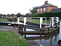
Swarkestone Lock and Keeper's House
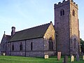
Swarkestone Church
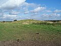
Swarkestone Lowes


Outside links
| ("Wikimedia Commons" has material about Swarkestone) |
References
- ↑ 1.0 1.1 Domesday Book: A Complete Translation. London: Penguin, 2003. ISBN 0-14-143994-7 p.742 & 749
- ↑ 2.0 2.1 2.2 2.3 2.4 2.5 2.6 2.7 2.8 Wadd, Barbara (2007). More Ghost Walks in Derbyshire. Wiltshire: Cromwell Press. ISBN 978-1-85983-556-2.
- ↑ 3.0 3.1 Swarkestone Bridge and Causeway, English Heritage, retrieved 7 September 2014
- ↑ Pevsner N, The Buildings of England . Derbyshire 2nd edition revised (1978) by Elizabeth Williamson, Penguin Books. 'Swarkeston', p.337
- ↑ A CAR that caused a fatal crash on Swarkestone Bridge should not have been on the road, according to a police vehicle examiner. | This is Derbyshire
- ↑ Beaker Folk site found in Britain New York Times December 1956
- ↑ National Heritage List 1019060: Lows Barrow
- ↑ Landmark Trust - Swarkestone Pavilion