Snelston
| Snelston | |
| Derbyshire | |
|---|---|
 The lodge and church | |
| Location | |
| Grid reference: | SK151434 |
| Location: | 52°59’17"N, 1°46’34"W |
| Data | |
| Population: | 202 (2011) |
| Post town: | Ashbourne |
| Postcode: | DE6 |
| Local Government | |
| Council: | Derbyshire Dales |
Snelston is a village three miles south-west of Ashbourne, in Derbyshire. The wider parish includes Anacrehill, and the population of this parish was recorded in the 2011 census as 202.
A tributary of the River Dove flows through the middle of the village, to join the Dove itself just three-quarters of a mile to the east. The River Dove marks the border of Staffordshire, and is crossed by a footbridge known as the Toadhole Footbridge.

About the village
The parish church is St Peter's Church. It was substantially rebuilt (except for the tower) in 1825.[1] It is one of the few churches to have had dances regularly held on the roof.[2]
Snelston Hall was the great house of the village, built in 1827 and demolished in 1951. The local squire, John Harrison had the village remodelled and a new school built in 1847. The village buildings were designed by the architect Lewis Nockalls Cottingham, as a 'model village'.
Pictures
| ("Wikimedia Commons" has material about Snelston) |
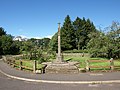
The war memorial
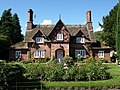
The Old Post Office
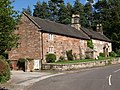
School Farm
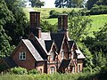
Brook Cottages
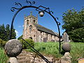
Church of St. Peter

Nave of the church of St. Peter
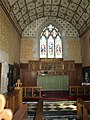
Sanctuary of the church of St. Peter


Outside links
- Snelston at DerbyshireUK
- Snelston.com
References
- ↑ Nikolaus Pevsner: The Buildings of England: Derbyshire, 1953; 1978 Penguin Books ISBN 978-0-300-09591-3
- ↑ Bowyer, L.J. Rev. 1953. The Ancient Parish of Norbury. Ashbourne. J.B. Henstock. Page 29.