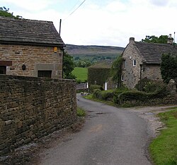
Shatton
From Wikishire
Revision as of 16:48, 2 June 2016 by RB (Talk | contribs) (Created page with "{{Infobox town |name=Shatton |county=Derbyshire |picture=Shatton - 177358.jpg |picture caption=Shatton. |os grid ref=SK198823 |latitude=53.337641 |longitude=-1.703133 |populat...")
| Shatton | |
| Derbyshire | |
|---|---|
 Shatton. | |
| Location | |
| Grid reference: | SK198823 |
| Location: | 53°20’16"N, 1°42’11"W |
| Data | |
| Population: | 136 (2011) |
| Post town: | Hope Valley |
| Postcode: | S33 |
| Local Government | |
| Council: | High Peak |
Shatton is a hamlet in the Hope Valley of northern Derbyshire, on the south side of the River Noe, a tributary of the upper River Derwent which runs down the valley. A mile to the west, upstream, is another hamlet, Brough-on-Noe, with which it forms a little civil parish ('Brough and Shatton')
Both hamlets are in the High Peak, with a combined population of just 136 at the 2011 Census. There is a friendly rivalry between the two hamlets, which contest numerous sports competitions throughout the year.