Difference between revisions of "Sgùrr Alasdair"
(Created page with '{{infobox hill |name=Sgùrr Alasdair |county=Inverness-shire |island=Skye |range=Cuillin |picture=sgurr_alasdair2.jpg |munro number=154 |height=3,255 feet |os grid ref=NG450207 }…') |
m |
||
| (One intermediate revision by the same user not shown) | |||
| Line 4: | Line 4: | ||
|island=Skye | |island=Skye | ||
|range=Cuillin | |range=Cuillin | ||
| − | |picture= | + | |SMC=17 |
| + | |picture=Sgurr alasdair.jpg | ||
|munro number=154 | |munro number=154 | ||
|height=3,255 feet | |height=3,255 feet | ||
| Line 19: | Line 20: | ||
==Outside links== | ==Outside links== | ||
| + | {{commons|Sgurr Alasdair}} | ||
*Computer-generated virtual panoramas: | *Computer-generated virtual panoramas: | ||
**[http://www.viewfinderpanoramas.org/panoramas/ISL/Skye_Alasdair.gif Sgùrr Alasdair] | **[http://www.viewfinderpanoramas.org/panoramas/ISL/Skye_Alasdair.gif Sgùrr Alasdair] | ||
**[http://www.viewfinderpanoramas.org/panoramas.html Index] | **[http://www.viewfinderpanoramas.org/panoramas.html Index] | ||
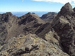
| + | [[File:Sgurr Alasdair from Sgurr Mhic Choinnich - geograph.org.uk - 1356705.jpg|right|250px|Sgurr Alasdair from Sgurr Mhic Choinnich]] | ||
==References== | ==References== | ||
{{reflist|2}} | {{reflist|2}} | ||
| Line 28: | Line 31: | ||
{{DEFAULTSORT:Sgurr Alasdair}} | {{DEFAULTSORT:Sgurr Alasdair}} | ||
| − | + | {{Munro}} | |
Latest revision as of 13:37, 20 October 2013
| Sgùrr Alasdair | |||
| Inverness-shire | |||
|---|---|---|---|

| |||
| Range: | Cuillin | ||
| Skye | |||
| Summit: | 3,255 feet NG450207 | ||
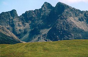
At 3,255 feet, Sgùrr Alasdair is the highest peak of the Black Cuillin, and the highest peak on the Isle of Skye, Inverness-shire. Like the rest of the range it is composed of gabbro, a rock with excellent grip for mountaineering.
Ascent
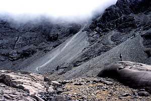
As with other hills of the Cuillin, a head for heights and scrambling ability are needed to attain the summit. The least technical route follows a feature known as the "Great Stone Chute" – a line of scree that leads up from the corrie named Coire Lagan to join a col on the main ridge. From this col, a pleasant scramble (Grade 2 standard) up the well scratched east ridge leads to the narrow summit.[1]
Other routes require scrambling ability or rock climbing; while there are rock climbs directly up the flanks, the only other way of reaching the summit via a ridge is the south-west ridge from the summit of Sgùrr Sgumain, a Grade 3 scramble that begins up a scratched chimney. The summit of Sgùrr Alasdair can be attained by a short detour (from Sgùrr Theàrlaich) off the main ridge by climbers undertaking the full traverse of the Cuillin ridge, or by those following the circuit of Coire Lagan.
Outside links
| ("Wikimedia Commons" has material about Sgùrr Alasdair) |
- Computer-generated virtual panoramas:
References
- ↑ The Islands of Scotland, Scottish Mountain Club Guidebook (1989 edition).
| Munros in SMC Area SMC Section 17 - The Islands |
|---|
|
Am Basteir • Ben More • Blaven • Bruach na Frithe • Inaccessible Pinnacle • Sgùrr a' Ghreadaidh • Sgùrr a' Mhadaidh • Sgùrr Alasdair • Sgùrr Dubh Mòr • Sgùrr MhicChoinnich • Sgurr na Banachdich • Sgùrr nan Eag • Sgùrr nan Gillean |

