Rosthwaite, Lancashire
From Wikishire
Revision as of 20:03, 27 February 2017 by Owain (Talk | contribs) (Created page with "{{infobox town |name=Rosthwaite |county=Lancaster |latitude=54.299748 |longitude=-3.168697 |LG district=South Lakeland |constituency=Westmorland and Lonsdale |post town=Broug...")
| Rosthwaite | |
| Lancashire | |
|---|---|
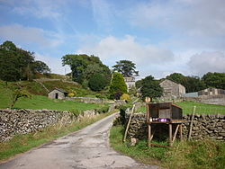
 High Rosthwaite Farm | |
| Location | |
| Grid reference: | SD239899 |
| Location: | 54°17’59"N, 3°10’7"W |
| Data | |
| Post town: | Broughton in Furness |
| Postcode: | LA20 |
| Dialling code: | 01229 |
| Local Government | |
| Council: | Westmorland & Furness |
| Parliamentary constituency: |
Westmorland and Lonsdale |
Rosthwaite is a settlement in the the Furness part of Lancashire. It is situated some three miles north-east of Broughton-in-Furness, off the A593 road.
Another Rosthwaite exists in the Lake District, some 40 miles to the north in Borrowdale, Cumberland.
| ("Wikimedia Commons" has material about Rosthwaite, Lancashire) |