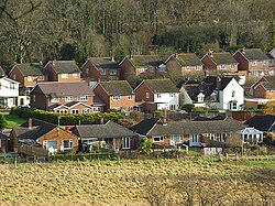
Middle Assendon
From Wikishire
Revision as of 13:46, 23 February 2024 by RB (Talk | contribs) (Created page with "{{Infobox town |name=Middle Assendon |county=Oxfordshire |picture=Middle Assendon - geograph.org.uk - 627335.jpg |picture caption= |os grid ref=SU739856 |latitude=51.5649 |lon...")
| Middle Assendon | |
| Oxfordshire | |
|---|---|

| |
| Location | |
| Grid reference: | SU739856 |
| Location: | 51°33’54"N, 0°56’5"W |
| Data | |
| Post town: | Henley-on-Thames |
| Postcode: | RG9 |
| Dialling code: | 01491 |
| Local Government | |
| Council: | South Oxfordshire |
| Parliamentary constituency: |
Henley |
| Website: | Bix and Assendon website |
Middle Assendon is a village in the south-east of Oxfordshire, in the Stonor valley in the Chiltern Hills, about half a mile north of Lower Assendon and two miles north-west of Henley-on-Thames. The village has a public house, the Rainbow Inn
Outside links
| ("Wikimedia Commons" has material about Middle Assendon) |