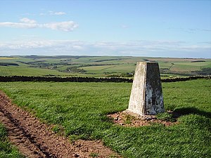
Horseley Hill
From Wikishire
Revision as of 22:36, 16 November 2016 by RB (Talk | contribs) (Created page with "{{Infobox hill |name=Horseley Hill |county=Berwickshire |picture=Horseley Hill - geograph.org.uk - 176159.jpg |picture caption=The summit of Horseley Hill |range=Lammermuir |o...")
| Horseley Hill | |||
| Berwickshire | |||
|---|---|---|---|
 The summit of Horseley Hill | |||
| Range: | Lammermuir | ||
| Summit: | 859 feet NT832620 55°51’6"N, 2°16’8"W | ||
Horseley Hill is a modest hill of 859 feet at the extreme north-eastern end of Lammermuir. It is to the south of the dale of the Eye Water, in Berwickshire. Its summit is just over half a mile south of Horseley hamlet and a mile north-west of Auchencrow; and two and a half miles south of Grantshouse.
There is a clutch of cottages by the summit.
The summit iscrowned with the earthworks of an ancient hillfort, known as Warlawbank, and beside it more prosaically a radio transmitter mast.