Difference between revisions of "Highmoor, Oxfordshire"
From Wikishire
(Created page with "{{Infobox town |name=Highmoor |county=Oxfordshire |picture=Dog and Duck, Highmoor - geograph.org.uk - 2884834.jpg |picture caption=The old Dog and Duck, Highmoor |os grid ref=...") |
(No difference)
|
Latest revision as of 23:31, 20 February 2024
| Highmoor | |
| Oxfordshire | |
|---|---|
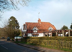
 The old Dog and Duck, Highmoor | |
| Location | |
| Grid reference: | SU700850 |
| Location: | 51°33’34"N, 0°59’25"W |
| Data | |
| Population: | 278 (2011, with Satwell) |
| Post town: | Henley-on-Thames |
| Postcode: | RG9 |
| Dialling code: | 01491 |
| Local Government | |
| Council: | South Oxfordshire |
| Parliamentary constituency: |
Henley |
Highmoor is a village in the Chiltern Hills in Oxfordshire, about four miles west of Henley-on-Thames. The parish includes the hamlet of Satwell.
The parish church, St Paul, at Highmoor Cross was designed by the architect Joseph Morris of Reading and built by Robert Owthwaite of Henley-on-Thames in 1859 as a chapel of ease by the vicar of Rotherfield Peppard to cater for the wider rural population of the parish. Highmoor later became a separate parish but the church was closed by a pastoral order in June 2012 as a result of a dwindling congregation, and was sold.
Highmoor has one pub: the Rising Sun at Witheridge Hill. Another, the Dog and Duck near Highmoor Cross, closed in December 2011.
Outside links
| ("Wikimedia Commons" has material about Highmoor, Oxfordshire) |
