Hardwick by the Windrush
From Wikishire
Revision as of 19:36, 20 February 2024 by RB (Talk | contribs) (Created page with "{{hatnote|Not to be confused with Hardwick near Hethe, also in Oxfordshire}} {{Infobox town |name=Hardwick |county=Oxfordshire |picture=HardwickCokethorpe...")
Not to be confused with Hardwick near Hethe, also in Oxfordshire
| Hardwick | |
| Oxfordshire | |
|---|---|
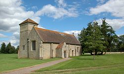
 Cokethorpe School chapel, Hardwick | |
| Location | |
| Grid reference: | SP378060 |
| Location: | 51°45’6"N, 1°27’10"W |
| Data | |
| Post town: | Witney |
| Postcode: | OX29 |
| Dialling code: | 01993 |
| Local Government | |
| Council: | West Oxfordshire |
| Parliamentary constituency: |
Witney |
Hardwick is a village in the west of Oxfordshire, sitting on the south bank of the River Windrush. The river here is in two main, widely separated, streams, with many manmade ponds between them. The old parish church, St Mary's, is now the chapel of Cokethorpe School.
The village is on the A415 road about two and a half miles south-east and downstream of Witney.
Hardwick was historically a hamlet or chapelry in the ancient parish of Ducklington.
References
- A History of the County of Oxford - Volume 13 pp 110-118: Ducklington: Introduction (Victoria County History)