Difference between revisions of "Forty Green, Penn"
From Wikishire
(→Outside links) |
|||
| Line 21: | Line 21: | ||
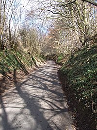
[[File:Lane near Forty Green - geograph.org.uk - 150577.jpg|right|thumb|200px|A lane near Forty Green]] | [[File:Lane near Forty Green - geograph.org.uk - 150577.jpg|right|thumb|200px|A lane near Forty Green]] | ||
==Outside links== | ==Outside links== | ||
| + | {{commons}} | ||
*[http://www.chiltern.gov.uk/downloads/fortygreenpubwalk_1.pdf Forty Green Pub Walk] at Chiltern District Council | *[http://www.chiltern.gov.uk/downloads/fortygreenpubwalk_1.pdf Forty Green Pub Walk] at Chiltern District Council | ||
{{stub}} | {{stub}} | ||
Revision as of 00:43, 1 January 2016
| Forty Green | |
| Buckinghamshire | |
|---|---|
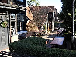
 The Royal Standard of England, Forty Green | |
| Location | |
| Grid reference: | SU922919 |
| Location: | 51°37’7"N, 0°40’6"W |
| Data | |
| Postcode: | HP9 |
| Local Government | |
| Council: | Buckinghamshire |
Forty Green is a hamlet in the parish of Penn in Buckinghamshire, though found south of Penn village itslef, by Knotty Green (itself a suburb now of Beaconsfield). Notwithstanding its closeness to the townscape, Forty Green manages to maintain a delightful rural distinctness, all placed within the Chiltern Hills.
The village pub, The Royal Standard of England, claims to be the oldest pub in the land, and its early mediæval timbers, with the marks of the carpenters' adzes still upon them, tell of venerable age.
Outside links
| ("Wikimedia Commons" has material about Forty Green, Penn) |
- Forty Green Pub Walk at Chiltern District Council
