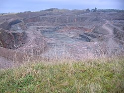
Eskett
From Wikishire
Revision as of 20:48, 10 July 2017 by RB (Talk | contribs) (Created page with "{{Infobox town |name=Eskett |county=Cumberland |picture=Eskett Quarry. - geograph.org.uk - 89845.jpg |picture caption=Eskett Quarry |os grid ref=NY052171 |latitude=54.541 |lon...")
| Eskett | |
| Cumberland | |
|---|---|
 Eskett Quarry | |
| Location | |
| Grid reference: | NY052171 |
| Location: | 54°32’28"N, 3°27’50"W |
| Data | |
| Post town: | Frizington |
| Postcode: | CA26 |
| Dialling code: | 01524 |
| Local Government | |
| Council: | Cumberland |
| Parliamentary constituency: |
Copeland |
Eskett is a hamlet in the west of Cumberland, inland above Frizington (north-east of Cleator Moor) on the slopes rising up to the Lake District fells.
Geologically the area is known for its limestone formation,[1] and Eskett Quarry produces igneous / metamorphic aggregates.[2]
Outside links
| ("Wikimedia Commons" has material about Eskett) |
References
- ↑ Waters, C. N. (15 September 2011). A Revised Correlation of Carboniferous Rocks in the British Isles. Geological Society. p. 86. ISBN 978-1-86239-333-2. https://books.google.com/books?id=B-anbPLFd7QC&pg=PA86. Retrieved 19 July 2012.
- ↑ Eskett Quarry: Agg-Net.com