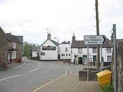
Cynwyd
| Cynwyd | |
| Merionethshire | |
|---|---|
 The Square | |
| Location | |
| Grid reference: | SJ0541 |
| Location: | 52°57’32"N, 3°24’22"W |
| Data | |
| Population: | 528 (2001) |
| Post town: | Corwen |
| Postcode: | LL21 |
| Dialling code: | 01490 |
| Local Government | |
| Council: | Denbighshire |
| Parliamentary constituency: |
Clwyd South |
Cynwyd is a village and parish in the Edeirnion area of Merionethshire, located about two miles south-west of Corwen. It had a population of 528 in 2001,[1] and is home to a large factory, run by Ifor Williams Trailers.
Gwerclas Hall is situated approximately a mile north-west of Cynwyd village. The present grade II* listed building dates mainly to 1767 and was built for Hugh Hughes Lloyd, replacing a house that had stood on the site for several hundred years. In was constructed in three storeys with a three-bay frontage and a central pedimented porch entrance.[2] The Gwerclas estate became part of the Rhug estate in 1824 on the death of Richard Hughes until it was sold in 1972.
Cynwyd railway station was formerly a station on the Ruabon to Barmouth line; it closed to passengers on 18 January 1965.
Contents
Pubs
Local pubs include:
- The Blue Lion
- The Prince of Wales
Schools
- Ysgol Maeshyfryd is the local primary school.
References
- ↑ Office for National Statistics : Census 2000 : Parish Headcounts : Denbighshire Retrieved 14 January 2010
- ↑ "Georgian face of Gwerclas Hall". The Free Library. http://www.thefreelibrary.com/Georgian+face+of+Gwerclas+Hall.-a0135059508. Retrieved 6 January 2014.