Difference between revisions of "Croxby"
(Created page with "{{Infobox town |name=Croxby |county=Lincolnshire |picture=All saints' church, Croxby, Lincs. - geograph.org.uk - 45776.jpg |picture caption=All Saints, Croxby |os grid ref=TF1...") |
|||
| Line 13: | Line 13: | ||
|constituency=Gainsborough | |constituency=Gainsborough | ||
}} | }} | ||
| − | '''Croxby''' is a tiny hamlet, barely more than a few houses, in [[Lindsey]], the northern part of [[Lincolnshire]]. It is to be found on the Waither Beck a mile west of a village barely larger, [[ | + | '''Croxby''' is a tiny hamlet, barely more than a few houses, in [[Lindsey]], the northern part of [[Lincolnshire]]. It is to be found on the Waither Beck a mile west of a village barely larger, [[Thorganby]], and of about five miles east of [[Caistor]]. A atellite halt, '''Croxby Top''' is just to the west, on the lane to [[Rothwell, Lincolnshire|Rothwell]]. |
The site of a deserted mediæval village, the original Croxby, lies to the north-east of the church, with Croxby Hall standing at the bottom, and standing beside a narrow stream running through a chalk valley.<ref>{{pastscape|351782|Croxby}}</ref> At the time of the [[Domesday Book]], this lost Croxby had a population of 36.<ref>{{lincstothepast|231965|Deserted mediæval village remains, Croxby}}</ref> | The site of a deserted mediæval village, the original Croxby, lies to the north-east of the church, with Croxby Hall standing at the bottom, and standing beside a narrow stream running through a chalk valley.<ref>{{pastscape|351782|Croxby}}</ref> At the time of the [[Domesday Book]], this lost Croxby had a population of 36.<ref>{{lincstothepast|231965|Deserted mediæval village remains, Croxby}}</ref> | ||
Latest revision as of 22:19, 27 November 2020
| Croxby | |
| Lincolnshire | |
|---|---|
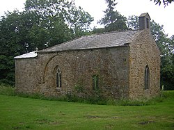
 All Saints, Croxby | |
| Location | |
| Grid reference: | TF189982 |
| Location: | 53°28’3"N, 0°12’33"W |
| Data | |
| Post town: | Market Rasen |
| Postcode: | LN7 |
| Local Government | |
| Council: | West Lindsey |
| Parliamentary constituency: |
Gainsborough |
Croxby is a tiny hamlet, barely more than a few houses, in Lindsey, the northern part of Lincolnshire. It is to be found on the Waither Beck a mile west of a village barely larger, Thorganby, and of about five miles east of Caistor. A atellite halt, Croxby Top is just to the west, on the lane to Rothwell.
The site of a deserted mediæval village, the original Croxby, lies to the north-east of the church, with Croxby Hall standing at the bottom, and standing beside a narrow stream running through a chalk valley.[1] At the time of the Domesday Book, this lost Croxby had a population of 36.[2]
The parish church, All Saints, is a Grade II* listed building of ironstone dating from the 12th century, with later additions and restorations. The font is also 12th-century.[3]
Croxby Hall is a Grade II* listed building of red brick dating from 1730.[4]
Outside links
References
- ↑ National Monuments Record: No. 351782 – Croxby
- ↑ Deserted mediæval village remains, Croxby: Lincs to the Past
- ↑ National Heritage List 1063478: Church of All Saints, Market Rasen (Grade II* listing)
- ↑ National Heritage List 1359756: Croxby Hall, Market Rasen (Grade II* listing)