Difference between revisions of "Clerke Rocks"
(Created page with '{{Infobox island |name=Clerke Rocks |territory=South Georgia and the South Sandwich Islands |group=South Georgia |picture=Cook-1777.jpg |picture caption=The Clerke Rocks on Cook'…') |
m |
||
| Line 7: | Line 7: | ||
|map= | |map= | ||
|map caption= | |map caption= | ||
| − | |latitude= | + | |latitude=-55.0667 |
| − | |longitude= | + | |longitude=-34.6833 |
|highest point= | |highest point= | ||
|population=0 | |population=0 | ||
Revision as of 14:55, 3 August 2014
| Clerke Rocks | |
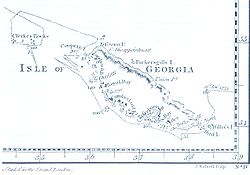
 The Clerke Rocks on Cook's map (north at the bottom) | |
|---|---|
| Location | |
| Location: | 55°4’0"S, 34°40’60"W |
| Data | |
| Population: | 0 |
The Clerke Rocks are a group of small rocky islands some 35 miles southeast of South Georgia that extend 5 miles from east to west. The Clerke Rocks include The Office Boys at the northeastern end and Nobby at the south-eastern end of the group. The islands belong to the British overseas territory of South Georgia and the South Sandwich Islands.
The islands were discovered in 1775 by a British expedition under Captain James Cook, who named them for Charles Clerke, an officer on HMS Resolution, who first saw the rocks.
As on the Shag Rocks, cormorants make up a large part of the bird population.
References
| South Georgia and the South Sandwich Islands | |
|---|---|
| South Georgia: | Annenkov Island • Bird Island • Clerke Rocks • Cooper Island • Grass Island • Kupriyanov Islands • Pickersgill Islands • Saddle Island • Shag Rocks • South Georgia • Welcome Islands • Willis Islands • Trinity Island • Grassholm • Black Rocks • Black Rock |
| South Sandwich Islands: |
Bellingshausen • Bristol • Candlemas • Cook • Leskov • Montagu • Saunders • Thule • Vindication • Visokoi • Zavodovski |