Difference between revisions of "Chapel Hill, Monmouthshire"
From Wikishire
(Redirected page to Tintern) |
|||
| Line 1: | Line 1: | ||
| − | + | {{county|Monmouthshire}} | |
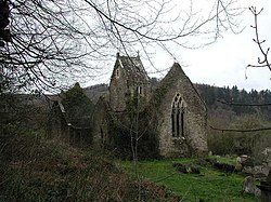
| + | [[File:Chapel Hill (Llanandras) Ruins of St Mary's Church - geograph.org.uk - 69765.jpg|thumb|250px|Ruins of St Mary's Church, Chapel Hill]] | ||
| + | '''Chapel Hill''' is an ancient parish in south-eastern [[Monmouthshire]] adjacent to the [[River Wye]] which here forms the border with [[Gloucestershire]]. It takes in a broad sweep of the right bank of the Wye from [[Tintern]] in the north to [[St Arvans]] in the south. Adjacent parishes are Tintern Parva and [[Trellech]] to the north; [[Tidenham]] (in Gloucestershire) to the east; [[Newchurch, Monmouthshire|Newchurch]] to the west; and [[Penterry]] and St Arvans to the south. The population in 2011 was 287. | ||
| + | |||
| + | The parish church, dedicated to St Mary was destroyed by fire in 1977. | ||
| + | |||
| + | ==Outside links== | ||
| + | *Location map: {{wmap|51.6882|-2.6805|zoom=13}} | ||
[[Category:Towns and villages in Monmouthshire]] | [[Category:Towns and villages in Monmouthshire]] | ||
| + | {{stub}} | ||
Revision as of 13:17, 9 May 2016
Chapel Hill is an ancient parish in south-eastern Monmouthshire adjacent to the River Wye which here forms the border with Gloucestershire. It takes in a broad sweep of the right bank of the Wye from Tintern in the north to St Arvans in the south. Adjacent parishes are Tintern Parva and Trellech to the north; Tidenham (in Gloucestershire) to the east; Newchurch to the west; and Penterry and St Arvans to the south. The population in 2011 was 287.
The parish church, dedicated to St Mary was destroyed by fire in 1977.
Outside links
- Location map: 51°41’18"N, 2°40’50"W
