Catcliffe
| Catcliffe | |
| Yorkshire West Riding | |
|---|---|
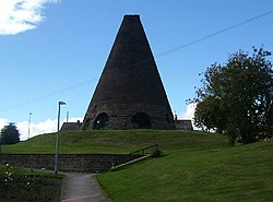
 The Catcliffe glass cone | |
| Location | |
| Grid reference: | SK425885 |
| Location: | 53°23’30"N, 1°21’45"W |
| Data | |
| Population: | 1,766 (2001) |
| Post town: | Rotherham |
| Postcode: | S60 |
| Dialling code: | 01709 |
| Local Government | |
| Council: | Rotherham |
| Parliamentary constituency: |
Rotherham |
Catcliffe is a village on the north-west bank of the River Rother in the West Riding of Yorkshire, about two and a half miles south of Rotherham and four miles east of Sheffield City Centre.
History
Catcliffe is mentioned in the Domesday Book of 1086. Its name is presumed to mean exactly what what it says: "cat cliff".
In 1740 William Fenney established a glassworks here. The site was chosen, amongst other reasons, for being 10½ miles away from Fenney's a glassworks in Bolsterstone, formerly owned by his mother-in-law—the terms of her will prevented him from setting up a glassworks within 10 miles of the town. One of the cones of this glassworks still exists: it is the oldest surviving structure of its type in Western Europe and a Grade I listed building[1] and a Scheduled Ancient Monument.
On 25 June 2007 the village was evacuated because of fears that cracks in the dam at Ulley reservoir could lead to widespread flooding in the valley.
Catcliffe railway station opened on 30 April 1900 and closed on 11 September 1939.
Geography
Catcliffe stands in the floor of the Rother Valley, on the west side of the River Rother. The village is susceptible to flooding and was badly affected by the floods of June 2007.[2]
Sights about the village
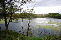
As well as the glass cone, the centre of the village is dominated by a nine-arch viaduct that was built in 1901 to carry the Sheffield District Railway across the River Rother.[3] Catcliffe Flash, to the south of the village, is a local nature reserve that is made up of a lake and marshland formed as the elevation of the land beside the River Rother dropped due to coal mining subsidence.[4]
Sports
The village had its own football team, Catcliffe FC, which played in the FA Cup during the 1900s.
A playing field at Catcliffe Poplar Way, on Orgreave Road is a Queen Elizabeth II Field.
Outside links
| ("Wikimedia Commons" has material about Catcliffe) |
References
- ↑ National Heritage List 10204662The Glassworks Cone: Glassworks Cone Catcliffe
- ↑ "Residents welcome flood defence". BBC News (BBC). 2008-05-29. http://news.bbc.co.uk/1/hi/england/south_yorkshire/7425520.stm. Retrieved 2009-01-18.
- ↑ Batty, S. (1984). Rail Centres: Sheffield. Shepperton, Surrey: Ian Allan Limited. p. 50. ISBN 1-901945-21-9.
- ↑ "Catcliffe Flash LNR". Rotherham Metropolitan Borough Council. http://www.rotherham.gov.uk/graphics/Leisure/Countryside+and+Wildlife/Local+Nature+Reserves/Catcliffe+Flash.htm. Retrieved 2009-01-16.
