Canklow
From Wikishire
| Canklow | |
| Yorkshire West Riding | |
|---|---|
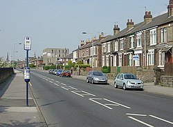
 Canklow Road, the main street of the settlement | |
| Location | |
| Grid reference: | SK425914 |
| Location: | 53°25’1"N, 1°21’36"W |
| Data | |
| Population: | 1,463 (2001) |
| Post town: | Rotherham |
| Postcode: | S60 |
| Dialling code: | 01709 |
| Local Government | |
| Council: | Rotherham |
| Parliamentary constituency: |
Rotherham |
Canklow is a village which has become a suburb of Rotherham in the West Riding of Yorkshire. It is less than a mile south of Rotherham town centre and approximately four miles north-east of Sheffield city centre.
History
Canklow was created as a post Second World War council housing area.[1] At the southern end of the estate there was once a coal mine, Rotherham Main Colliery. The mine opened in 1890 and closed in 1954.[2]
As in many former coal mining villages, Canklow has suffered. In 1981 the census revealed a male unemployment rate for Canklow of 42.1%, just under four times the national average.[3] The area at the time suffered high unemployment, a heroin problem and a suicide rate well above the high average[4]
Outside links
References
- ↑ Williams,Clifford (1997) 'Offenders and Victims of Crime;Mediation and reparation in the criminal justice system, including case studies of mediation and reparation projects organised by the probation service' Unpublished PhD University of Bradford (1997) Appendix 4 Area Profile of Canklow
- ↑ Williams (1997) op cit
- ↑ Williams (1997) op cit
- ↑ Yorkshire Post 20 May 1985 'The Heroin Nightmare' (Williams (1997) op cit page 277