Difference between revisions of "Caird Coast"
| Line 1: | Line 1: | ||
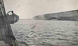
[[File:CairdCoast.jpg|thumb|right|250px|The sheer ice cliffs of the Caird Coast as seen by Shackleton's Expedition in January, 1915]] | [[File:CairdCoast.jpg|thumb|right|250px|The sheer ice cliffs of the Caird Coast as seen by Shackleton's Expedition in January, 1915]] | ||
| − | The '''Caird Coast''' is that portion of the coast of [[Coats Land]] in the [[British Antarctic Territory]] lying between the terminus of [[Stancomb-Wills Glacier]], in 20º00´W, and the vicinity of the [[Hayes Glacier]], in 27º54´W. | + | {{territory|BAT}} |
| + | The '''Caird Coast''' is that portion of the coast of [[Coats Land]] in the [[British Antarctic Territory]] lying between the terminus of [[Stancomb-Wills Glacier]], in 20º00´W, and the vicinity of the [[Hayes Glacier]], in 27º54´W, which can also be expressed as being between the [[Luitpold Coast]] and the boundary of the Norwegian territory (Kronprinsesse Martha Kyst of Dronning Maud Land). | ||
| − | In December 1914 and January 1915, as part of the British Imperial Trans-Antarctic Expedition, Ernest Shackleton named this coastland for Sir James Key Caird, patron of the expedition. Shackleton continued the exploration southward, joining Bruce's discovery to the | + | In December 1914 and January 1915, as part of the British Imperial Trans-Antarctic Expedition, Ernest Shackleton named this coastland for Sir James Key Caird, patron of the expedition. Shackleton continued the exploration southward, joining Bruce's discovery to the Luitpold Coast which Wilhelm Filchner had discovered from the ''Deutschland'' in 1912. |
(Shackleton's expedition was ultimately wrecked, the ''Endeavour'' trapped and crushed in the ice, and Caird's name was used again, for the famous lifeboat ''The James Caird'' in which Shackleton sailed from [[Elephant Island]] to [[South Georgia]] that his shipwrecked men could be rescued.) | (Shackleton's expedition was ultimately wrecked, the ''Endeavour'' trapped and crushed in the ice, and Caird's name was used again, for the famous lifeboat ''The James Caird'' in which Shackleton sailed from [[Elephant Island]] to [[South Georgia]] that his shipwrecked men could be rescued.) | ||
| + | |||
| + | ==Location== | ||
| + | *Location map: {{wmap|-75.8602|-24.6064}} | ||
==References== | ==References== | ||
{{reflist}} | {{reflist}} | ||
| + | *{{basgaz}} | ||
| − | [[Category:Coats Land]] | + | [[Category:Coasts of Coats Land]] |
| − | {{stub | + | {{stub}} |
Revision as of 21:56, 12 July 2020
The Caird Coast is that portion of the coast of Coats Land in the British Antarctic Territory lying between the terminus of Stancomb-Wills Glacier, in 20º00´W, and the vicinity of the Hayes Glacier, in 27º54´W, which can also be expressed as being between the Luitpold Coast and the boundary of the Norwegian territory (Kronprinsesse Martha Kyst of Dronning Maud Land).
In December 1914 and January 1915, as part of the British Imperial Trans-Antarctic Expedition, Ernest Shackleton named this coastland for Sir James Key Caird, patron of the expedition. Shackleton continued the exploration southward, joining Bruce's discovery to the Luitpold Coast which Wilhelm Filchner had discovered from the Deutschland in 1912.
(Shackleton's expedition was ultimately wrecked, the Endeavour trapped and crushed in the ice, and Caird's name was used again, for the famous lifeboat The James Caird in which Shackleton sailed from Elephant Island to South Georgia that his shipwrecked men could be rescued.)
Location
- Location map: 75°51’37"S, 24°36’23"W
References
- Gazetteer and Map of The British Antarctic Territory: Caird Coast
