Breighton
| Breighton | |
| Yorkshire East Riding | |
|---|---|
 Housing in Breighton | |
| Location | |
| Grid reference: | SE709339 |
| Location: | 53°47’49"N, 0°55’27"W |
| Data | |
| Postcode: | YO8 |
| Dialling code: | 01757 |
| Local Government | |
| Council: | East Riding of Yorkshire |
| Parliamentary constituency: |
Haltemprice and Howden |
Breighton is a village in the East Riding of Yorkshire, sitting on the east bank of the River Derwent, about five miles north-west of Howden and :Bubwith.
The name of the village is from the Old English Bricstune, and is recorded in the Domesday Book of 1086 as Briston.
History
This village is is believed to have been founded as a result of the Menthrope Ferry. Breighton village has existed since at least 1361, with it being recorded that the manor house was in Ruin at the time. By 1433 it had been rebuilt as Eleanor, the daughter of Sir Robert Roos, was born in the building which was recorded due to the requirement to verify the date of birth in 1499. Other than this information very little is publicly available about the village's history, particularly due to the more important and prominent village of Bubwith to the north.[1]
In 1672 the village was described as a ‘well-hearthed village’ and it seems to have been fairly wealthy, going by the hearth tax returns. The largest house at the time was the home of Mr Parish, who likely lived in the manor house at the time however this is not recorded. There were a number of landowners that had interests in the village at the time including the Archbishop of York who was the largest landowner in the area until the 1870s. After the Archbishop of York the Liversidges became lords of the manor, they kept ownership of the estates until 1918.[1]
To the north-west of the main village is the Breighton Ferry public house. From the Middle Ages until the 1930s a ferry operated across the Derwent to Menthorpe.[2] This ferry service no longer runs, however there is a large number of mooring points still in operation, used for storage of small river craft over the winter, as shown in the photo below in the gallery.
The village has had close ties to Bubwith to the north since its founding. These ties were strengthened in 1944 with the closure of Breighton's Wesleyan chapel, with the village's next closest church or place of worship being in Bubwith. The local school (Dames School) suffered a similar fate however the time of its destruction is not known.[1]
Nearby is RAF Breighton, built between 1940 and 1942 for No. 1 Group RAF, its first residents were the No. 460 Squadron RAAF. After the Second World War, the airfield was used to store Thor missiles, before finally closing in March 1964. It is currently used by the Real Aeroplane Company to house historic aircraft as well as for hosting air shows. RAF Breighton or Breighton Airfield, as it is now commonly known, has the ICAO Code of EGBR.
Events
An air show is held by the Real Aeroplane Company in the summer.[3] This is now a private event due to a series of accidents that have occurred over the years.
Pictures
| ("Wikimedia Commons" has material about Breighton) |

Breighton Airfield and Aeroplane Museum
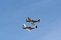
Mustangs Flying During Breighton Airshow
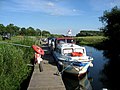
The River Derwent


Outside links
References
- ↑ 1.0 1.1 1.2 Atkinson, W. F.; Gilby, S.; Henley, John (1979). Bubwith : an East Yorkshire parish. Bubwith Village Trust. ISBN 0-905490-08-8. OCLC 16556652. http://worldcat.org/oclc/16556652.
- ↑ A History of the County of York: East Riding - Volume 3 pp 63-64: Menthorpe with Bowthorpe (Victoria County History)
- ↑ "Photos of Breighton Airshow". http://www.myforest.com/Us/Places/England/Yorkshire/Breighton/Airfield/Airshow/. Retrieved 15 March 2008.
- Gazetteer — A–Z of Towns Villages and Hamlets. East Riding of Yorkshire Council. 2006. p. 4.