Bramhope
| Bramhope | |
| Yorkshire West Riding | |
|---|---|
 Bramhope crossroads | |
| Location | |
| Grid reference: | SE253432 |
| Location: | 53°52’58"N, 1°36’34"W |
| Data | |
| Population: | 3,533 (2001) |
| Post town: | Leeds |
| Postcode: | LS16 |
| Dialling code: | 0113 |
| Local Government | |
| Council: | Leeds |
| Parliamentary constituency: |
Leeds North West |
Bramhope is a village in the West Riding of Yorkshire, to be found north of Holt Park and north east of Cookridge, nine miles north of Leeds city centre. The 2011 census recorded a parish population of 3,533.. The village is predominantly made up of large, privately owned houses.
The name Bramhope appears first in the Domesday Book of 1086 as Brahop and Bramhop, with later mediæval spellings including Bramhop(a) and Bramhop(p)e. The name seems to derive from the Old English words brom 'broom' and hop, a small valley, here referring to a small valley off Wharfedale,[1] probably the one through which flows Bramhope Beck.[2]
Contents
History

The earliest known settlement in the area was a British camp established off Moor Road. The Romans built a road through the area from Adel to Ilkley, traces of which remain in a field near Leeds Bradford Airport.[3]
In 1086, Bramhope was the manor of an Anglo-Saxon thegn, Uchill. In 1095 the manor passed to the Percy family, and in 1165 was sold to Ralph de Bramhope. In the 13th century the monasteries owned much of the land and had granges where sheep were grazed. The monks used tracks, such as Scotland Lane and Staircase Lane, as they travelled from their outlying granges to Kirkstall Abbey.[3]
The village had a small population until the 20th century. The Black Death of 1348-49 reduced the number of adults to 34, but this gradually increased to about 400 in 1900. Now it is approximately 3,400.[3] Water was drawn from private wells or the town well at the foot of Northgate (now Church Hill). The town well was restored in 1991 by the Bramhope History Group, and is located opposite St Giles' Church.[3] The plaque says that the well was exposed in 1991, so perhaps it had been lost for some time.[4]
Churches

At the Dissolution of the Monasteries under Henry VIII, the King gave the land to the Earl of Cumberland. In the 16th century the Dyneley family moved into the area and acquired Bramhope Hall. In 1649 they built the Puritan Chapel, which was taken over by the Church of England after the Restoration.[3] The chapel is one of only a few built during the Commonwealth period. It is said not to have been consecrated but nevertheless was regularly used for church services until 1881–82. The Puritan Chapel is a Grade I listed building.
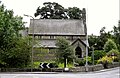
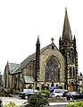
When the chapel proved too small for the growing population, St Giles' Church was built in 1881.[5] The original Methodist chapel was built in 1837 and replaced by the much bigger church in 1896.[3]
Road and railway

For many centuries travellers to the market towns in the vicinity used Otley Old Road. However, it was the Leeds to Otley turnpike road, with its tollhouses, opened in 1842, which routed travellers through the outskirts of Bramhope. It is along this route that motorists today travel between Leeds and the northwest. The milestones along the road were erected in 1850.[3]
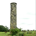
The railway was excavated under the village through the Bramhope Tunnel constructed between 1845 and 1849. The tunnel has an elaborate castellated northern entrance and there are many heaps of spoil and several ventilation shafts along its length. There is a replica of the tunnel entrance in Otley churchyard, erected as a memorial to the 24 men who lost their lives during the tunnel's construction.[3] A railway station has never been built at or near Bramhope.
Schools
A village school was built in Eastgate where the war memorial garden is situated. A plaque states "On this site in 1790 a Day School was erected by the Freehold (law)|freeholders and copyholders of Bramhope Township. It was also used as a Sunday School and Public Meeting Place. Demolished 1961". The school became overcrowded whilst tunnelling work for the railway was going on in the late 1840s. It was replaced by a larger building in 1873 in Breary Lane, next to the shopping parade. The present school, situated on Tredgold Crescent, was opened in 1961.[3]
Pictures
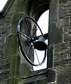
Bell on Puritan Church, 1649
St Giles' Church, 1881
Methodist Church, 1896
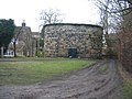
Old smithy, 1687
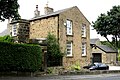
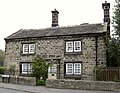
Old manor farm house, 1691
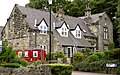
Old school house 1873, now flats
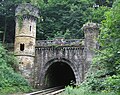
Bramhope Tunnel north portal with castellated towers
Sighting tower over Bramhope Tunnel route
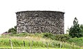
Ventilation shaft serving Bramhope Tunnel
Ventilation shaft in centre of Bramhope


Outside links
| ("Wikimedia Commons" has material about Bramhope) |
References
- ↑ Victor Watts (ed.), The Cambridge Dictionary of English Place-Names, Based on the Collections of the English Place-Name Society (Cambridge: Cambridge University Press, 2004), s.v. BRAMHOPE.
- ↑ Harry Parkin, Your City's Place-Names: Leeds, English Place-Name Society City-Names Series, 3 (Nottingham: English Place-Name Society, 2017), p. 27.
- ↑ 3.0 3.1 3.2 3.3 3.4 3.5 3.6 3.7 3.8 "Bramhope and Carlton Parish Council". A Brief History of Bramhope (source:A History of the Township of Bramhope' by W.F. Seals). 10 October 2000. http://www.bramhope.org/brhistry.htm.
- ↑ Hatton, Gordon (19 January 2009). "Geograph.org.uk". Photo of Old Well, Bramhope, and comments. https://www.geograph.org.uk/photo/1126068.
- ↑ "St Giles Bramhope". St Giles Church website. 2009. http://www.stgilesbramhope.org.uk/.