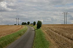
Boyton End, Suffolk
From Wikishire
Revision as of 22:52, 8 February 2017 by RB (Talk | contribs) (Created page with "{{Infobox town |name=Boyton End |county=Suffolk |picture=Cain's Hill, Boyton End - geograph.org.uk - 508311.jpg |picture caption= |os grid ref=TL719444 |latitude=52.071809 |lo...")
| Boyton End | |
| Suffolk | |
|---|---|

| |
| Location | |
| Grid reference: | TL719444 |
| Location: | 52°4’19"N, 0°30’27"E |
| Data | |
| Local Government | |
Boyton End is a village in the very south-west of Suffolk, less than a mile from the Essex border both to the south and to the west, which border is marked here by the River Stour. Haverhill is three miles to the west and the little village of Stoke-by-Clare is a mile and a half to the east.
Outside links
| ("Wikimedia Commons" has material about Boyton End, Suffolk) |