Barkston Ash
| Barkston Ash | |
| Yorkshire West Riding | |
|---|---|
 Boundary stone at the Main Street/A162 junction | |
| Location | |
| Grid reference: | SE491361 |
| Location: | 53°49’9"N, 1°15’16"W |
| Data | |
| Population: | 370 (2011[1]) |
| Post town: | Tadcaster |
| Postcode: | LS24 |
| Local Government | |
| Council: | Selby |
Barkston Ash is a small village and civil parish in the West Riding of Yorkshire, within the Barkston Ash Wapentake.[2][3] The civil parish originated as the township in the ancient parish of Sherburn-in-Elmet, and had a population of 370 in 2011.
Contents
History
The village dates back to at least 1090, when it was spelled Barcestone.[3] What is now the A162 London Road was a turnpike constructed in 1769: the Main Street and the major part of the village goes East from the junction with this. The ash tree that stands on the top of Main Street in Barkston Ash was often said to mark the centre of Yorkshire. It was replaced in the 1980s because of age and disease and a new tree was planted in its place. A section of the original tree was kept and is still available to see. According to a legend concerning Barkston's eponymous ash tree, anyone who spits at the tree is destined to be struck by lightning a year and a day later; an apocryphal figure, known as Jack Foll, is supposed to have suffered this fate. It is also said that until the eighteenth century the Barkston Ash folly -a form of mediæval football involving pigs’ bladders and lighteners (wooden staves)- was played by young men of the village. The game is supposed to have been commemorating Jack Foll.
Features
The village contains a small Church of England church, Holy Trinity, originally a chapel of ease constructed in 1880, but given its current name and status in 1974. There are two pubs, the Ash Tree (on the site of a former coaching inn) and the Boot and Shoe, a village hall and a primary school (dating from 1856).[4] There were formerly two shops and a post office on Main Street, now private residences.[3]
There are three 17th- to 19th-century stone Grade-II-listed houses near the junction of Main Street and Church Street: Laurel Farm,[5] Barkston House,[6] and Turpin Hall Farm.[7]

Ash Tree pub
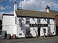
Boot and Shoe pub
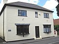
Former post office
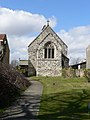
Holy Trinity Church


References
- ↑ UK Census (2011). "Local Area Report – Barkston Ash Parish (1170217377)". Nomis. Office for National Statistics. https://www.nomisweb.co.uk/sources/census_2011_ks/report?compare=1170217377. Retrieved 10 March 2018
- ↑ Lewis, Samuel. "Barkston". UK Genealogy Archives. https://ukga.org/lewis_eng/B/897.html. Retrieved 12 July 2018. "Transcribed from A Topographical Dictionary of England, by Samuel Lewis, 7th edition, published in 1848."
- ↑ 3.0 3.1 3.2 "About Barkston Ash". Barkston Ash Parish Council. http://barkstonash.co.uk/index.php/about. Retrieved 12 July 2018.
- ↑ "Barkston Ash Catholic Primary School". http://barkstonash.n-yorks.sch.uk/page.php?id=1966. Retrieved 26 April 2019.
- ↑ National Heritage List 1148434: Laurel Farm
- ↑ National Heritage List 1316334: Barkston House
- ↑ National Heritage List 1148433: Turpin Hall Farm
Outside links
| ("Wikimedia Commons" has material about Barkston Ash) |